
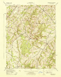
~ Germantown MD topo map, 1:31680 scale, 7.5 X 7.5 Minute, Historical, 1944
Germantown, Maryland, USGS topographic map dated 1944.
Includes geographic coordinates (latitude and longitude). This topographic map is suitable for hiking, camping, and exploring, or framing it as a wall map.
Printed on-demand using high resolution imagery, on heavy weight and acid free paper, or alternatively on a variety of synthetic materials.
Topos available on paper, Waterproof, Poly, or Tyvek. Usually shipping rolled, unless combined with other folded maps in one order.
- Product Number: USGS-5367690
- Free digital map download (high-resolution, GeoPDF): Germantown, Maryland (file size: 8 MB)
- Map Size: please refer to the dimensions of the GeoPDF map above
- Weight (paper map): ca. 55 grams
- Map Type: POD USGS Topographic Map
- Map Series: HTMC
- Map Verison: Historical
- Cell ID: 17119
- Scan ID: 257096
- Woodland Tint: Yes
- Aerial Photo Year: 1943
- Datum: NAD27
- Map Projection: Polyconic
- Map published by United States Army Corps of Engineers
- Map published by United States Department of War
- Map Language: English
- Scanner Resolution: 600 dpi
- Map Cell Name: Germantown
- Grid size: 7.5 X 7.5 Minute
- Date on map: 1944
- Map Scale: 1:31680
- Geographical region: Maryland, United States
Neighboring Maps:
All neighboring USGS topo maps are available for sale online at a variety of scales.
Spatial coverage:
Topo map Germantown, Maryland, covers the geographical area associated the following places:
- Germantown Estates - Germantown Park - Oak Ridge - Blackrock Hills - Black Hill - The Colony - Wilber - Greenridge Acres - Germantown View - Stoneridge - Blocktown - Old Germantown - Clarksbrook Estates - Cedar Creek Estates - Williamsburg Square - Pleasant Fields - Fountain View - Meadowbrook Estates - Lees Corner - Slidell - Clarksburg Heights - Blackrock Mill - Quince Orchard Valley - Brownstown - Quince Orchard Manor - Germantown - Comus - Farmingdale Estates - Thompsons Corner - Clarksburg - Boyds - Miles Corner - Burdette - Brownstown Estates - Liberty Heights - Waring (historical) - Kingsview Knolls - Bucklodge - North Germantown - Beau Monde Estates - Blackrock Estates - Running Brook Acres - Dawsonville
- Map Area ID: AREA39.2539.125-77.375-77.25
- Northwest corner Lat/Long code: USGSNW39.25-77.375
- Northeast corner Lat/Long code: USGSNE39.25-77.25
- Southwest corner Lat/Long code: USGSSW39.125-77.375
- Southeast corner Lat/Long code: USGSSE39.125-77.25
- Northern map edge Latitude: 39.25
- Southern map edge Latitude: 39.125
- Western map edge Longitude: -77.375
- Eastern map edge Longitude: -77.25


