
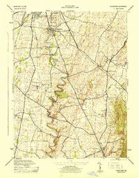
~ Funkstown MD topo map, 1:31680 scale, 7.5 X 7.5 Minute, Historical, 1944
Funkstown, Maryland, USGS topographic map dated 1944.
Includes geographic coordinates (latitude and longitude). This topographic map is suitable for hiking, camping, and exploring, or framing it as a wall map.
Printed on-demand using high resolution imagery, on heavy weight and acid free paper, or alternatively on a variety of synthetic materials.
Topos available on paper, Waterproof, Poly, or Tyvek. Usually shipping rolled, unless combined with other folded maps in one order.
- Product Number: USGS-5367686
- Free digital map download (high-resolution, GeoPDF): Funkstown, Maryland (file size: 8 MB)
- Map Size: please refer to the dimensions of the GeoPDF map above
- Weight (paper map): ca. 55 grams
- Map Type: POD USGS Topographic Map
- Map Series: HTMC
- Map Verison: Historical
- Cell ID: 16588
- Scan ID: 257094
- Woodland Tint: Yes
- Aerial Photo Year: 1943
- Datum: NAD27
- Map Projection: Polyconic
- Map published by United States Army Corps of Engineers
- Map published by United States Department of War
- Map Language: English
- Scanner Resolution: 600 dpi
- Map Cell Name: Funkstown
- Grid size: 7.5 X 7.5 Minute
- Date on map: 1944
- Map Scale: 1:31680
- Geographical region: Maryland, United States
Neighboring Maps:
All neighboring USGS topo maps are available for sale online at a variety of scales.
Spatial coverage:
Topo map Funkstown, Maryland, covers the geographical area associated the following places:
- Edgewood Hill - Mousetown - Longview Estates - Woodcrest Village - Tilghmanton Heights - Tilghmanton - Kinsey Heights - Vardo - Roxbury Hill - Antietam Manor - Fairplay - Antietam Overlook - Kline Mill - Mount Lena - Millpoint - Mountain View Estates - Funkstown - Roxbury - Boonsboro - San Mar - Londontowne - Lappans - Saint James Village - Mapleville - Cool Hollow Estates - Beaver Creek - Doub Meadow - El Rancho Mobile Home Park - Brightwood Acres - Emmertsville - Antietam Farmettes - Wagners Crossroads - Mount Pleasant - Breathedsville - Doubs Mill - Benevola - Burtner - Greystone Hills - Crestview - Green Hill
- Map Area ID: AREA39.62539.5-77.75-77.625
- Northwest corner Lat/Long code: USGSNW39.625-77.75
- Northeast corner Lat/Long code: USGSNE39.625-77.625
- Southwest corner Lat/Long code: USGSSW39.5-77.75
- Southeast corner Lat/Long code: USGSSE39.5-77.625
- Northern map edge Latitude: 39.625
- Southern map edge Latitude: 39.5
- Western map edge Longitude: -77.75
- Eastern map edge Longitude: -77.625


