
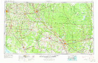
~ Valdosta GA topo map, 1:250000 scale, 1 X 2 Degree, Historical, 1954, updated 1967
Valdosta, Georgia, USGS topographic map dated 1954.
Includes geographic coordinates (latitude and longitude). This topographic map is suitable for hiking, camping, and exploring, or framing it as a wall map.
Printed on-demand using high resolution imagery, on heavy weight and acid free paper, or alternatively on a variety of synthetic materials.
Topos available on paper, Waterproof, Poly, or Tyvek. Usually shipping rolled, unless combined with other folded maps in one order.
- Product Number: USGS-5365400
- Free digital map download (high-resolution, GeoPDF): Valdosta, Georgia (file size: 17 MB)
- Map Size: please refer to the dimensions of the GeoPDF map above
- Weight (paper map): ca. 55 grams
- Map Type: POD USGS Topographic Map
- Map Series: HTMC
- Map Verison: Historical
- Cell ID: 69079
- Scan ID: 247854
- Imprint Year: 1967
- Woodland Tint: Yes
- Visual Version Number: 1
- Aerial Photo Year: 1951
- Edit Year: 1965
- Field Check Year: 1954
- Datum: Unstated
- Map Projection: Transverse Mercator
- Map published by United States Geological Survey
- Map Language: English
- Scanner Resolution: 600 dpi
- Map Cell Name: Valdosta
- Grid size: 1 X 2 Degree
- Date on map: 1954
- Map Scale: 1:250000
- Geographical region: Georgia, United States
Neighboring Maps:
All neighboring USGS topo maps are available for sale online at a variety of scales.
Spatial coverage:
Topo map Valdosta, Georgia, covers the geographical area associated the following places:
- Lamont - Hopeful Circle Village Mobile Home Park - Potter - Myrtis - Luraville - Okeafenoke Swamp (historical) - Prescott - Blacks Still - Fletcherville - Empress - Fenholloway - Bass - McLoughlin Heights - Hopkins - Wayne Friers Mobile Home Park - Greenville - Deer Run Mobile Home Park - Pavo - Dixie - Monks Crossing - Madison - Maines Devoe Mobile Home Park - Trailer Harbor Mobile Home Park - Leland - Ferry Landing - Mac's Mobile Home Park - Stokesville - Luther Thomas Mobile Home Park - Sargent - Newburn - Davis Park Mobile Home Park - Bessent - Fargo - Olustee - Goldies Mobile Home Park - Live Oak Pines Mobile Home Park - Eddy - Greens Crossing - West Valdosta - Williamsburg - Nash - Northwood - Virginias Trailer Park - Starr - Nugalla (historical) - Westgate Mobile Home Park - Morven - Atawalia (historical) - Rawls - Day - Fairview - Oakview Mobile Home Park - Manning - Ousley - Cypress Creek - Chauncey - Ernest - Magnolia - Clarking - Dellwood - Pine Top - Ellaville - Homestead Park - Pineland - Charter Oaks - Steckert - Piscola - Glen Saint Mary - Townsend - Midway - Macville (historical) - Holmes Trailer Park - Maxville - Dewey City - Dowling Park - Sanderson - Bailey - Pinetta - San Francisco de Oconi (historical) - Boyd - Spooner - Everett - Lois - Iddo - Blanton - Country Club Estates - Westgate Mobile Home Park - Raiford - Wilburn - Suwannee - Saint George - Kenny - Ebenezer - Wacissa (historical) - Delmar - Newco - Oaklawn - Forrest Place - Cherry Creek Hills - Bamburg
- Map Area ID: AREA3130-84-82
- Northwest corner Lat/Long code: USGSNW31-84
- Northeast corner Lat/Long code: USGSNE31-82
- Southwest corner Lat/Long code: USGSSW30-84
- Southeast corner Lat/Long code: USGSSE30-82
- Northern map edge Latitude: 31
- Southern map edge Latitude: 30
- Western map edge Longitude: -84
- Eastern map edge Longitude: -82


