
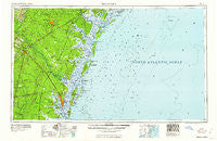
~ Brunswick GA topo map, 1:250000 scale, 1 X 2 Degree, Historical, 1961
Brunswick, Georgia, USGS topographic map dated 1961.
Includes geographic coordinates (latitude and longitude). This topographic map is suitable for hiking, camping, and exploring, or framing it as a wall map.
Printed on-demand using high resolution imagery, on heavy weight and acid free paper, or alternatively on a variety of synthetic materials.
Topos available on paper, Waterproof, Poly, or Tyvek. Usually shipping rolled, unless combined with other folded maps in one order.
- Product Number: USGS-5365354
- Free digital map download (high-resolution, GeoPDF): Brunswick, Georgia (file size: 13 MB)
- Map Size: please refer to the dimensions of the GeoPDF map above
- Weight (paper map): ca. 55 grams
- Map Type: POD USGS Topographic Map
- Map Series: HTMC
- Map Verison: Historical
- Cell ID: 68694
- Scan ID: 247832
- Woodland Tint: Yes
- Field Check Year: 1956
- Datum: Unstated
- Map Projection: Transverse Mercator
- Map published by United States Geological Survey
- Map Language: English
- Scanner Resolution: 600 dpi
- Map Cell Name: Brunswick
- Grid size: 1 X 2 Degree
- Date on map: 1961
- Map Scale: 1:250000
- Geographical region: Georgia, United States
Neighboring Maps:
All neighboring USGS topo maps are available for sale online at a variety of scales.
Spatial coverage:
Topo map Brunswick, Georgia, covers the geographical area associated the following places:
- Paradise Park - Jenks (historical) - Waverly - Oglethorpe Manor - Pine Ridge - Oak Bluff - High Hill Lake - Country Manor Mobile Home Park - Northwood Estates - Oglethorpe Park - Tarboro - Smiley (historical) - Retreat - Allenhurst - Pine Haven - Victory Manor Mobile Home Court - Rose Hill - Grove Point Mobile Home Estates - Taylors Creek (historical) - Wilmington Park - Bethel (historical) - Parade Rest - Village Bluff - Pyles Marsh - Oakhurst - Odessa - East End - Dock Junction - Oakview Mobile Home Park - Rio Vista - Glendale Gardens - Cherokee Village - Aimar - Doboy (historical) - Leedsgate - Pineview - Zuta - Evelyn - Deerwood Estates - Halfmoon Landing - Ellis Point - Rabbit Hill - Trudie - Leicht (historical) - Youngwood - Atkinson - Vernonburg - Madray Springs - Jesup - Epworth Acres - Mallory Park - Jones - Salter - Windward Acres - Pendarvis - McKinnon - Eagle Creek Mobile Home Community - Thornhill Mobile Home Park - Harrison Heights - Brunswick - Sunbury - Anguilla - Lynhurst - White Bluff - Darien - Halcyon Bluff - Carnigan - Country Club Estates - Piney Bluff - Grove Park - Tupelo Trail - Windsor on the Marsh - Doyles Mobile Home Park - Brewer (historical) - Noble - Jewtown - Parkwood - Cinder Hill - Chippewa Terrace - Elim - Pennick - Wilshire - Central Park - Glyndale - Darien Heights - Dyches Mobile Home Park - Lakeside Park - Coffee Bluff - Gum Branch - Dover Bluff - Dunham (historical) - Wildwood - Wefanie - Groveside Park - Sun Hill - Northwest Woods - Rivers End - Eulonia - Hortense - Wymberly on the Marsh
- Map Area ID: AREA3231-82-80
- Northwest corner Lat/Long code: USGSNW32-82
- Northeast corner Lat/Long code: USGSNE32-80
- Southwest corner Lat/Long code: USGSSW31-82
- Southeast corner Lat/Long code: USGSSE31-80
- Northern map edge Latitude: 32
- Southern map edge Latitude: 31
- Western map edge Longitude: -82
- Eastern map edge Longitude: -80


