
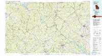
~ Toccoa GA topo map, 1:100000 scale, 30 X 60 Minute, Historical, 1981, updated 1982
Toccoa, Georgia, USGS topographic map dated 1981.
Includes geographic coordinates (latitude and longitude). This topographic map is suitable for hiking, camping, and exploring, or framing it as a wall map.
Printed on-demand using high resolution imagery, on heavy weight and acid free paper, or alternatively on a variety of synthetic materials.
Topos available on paper, Waterproof, Poly, or Tyvek. Usually shipping rolled, unless combined with other folded maps in one order.
- Product Number: USGS-5365128
- Free digital map download (high-resolution, GeoPDF): Toccoa, Georgia (file size: 29 MB)
- Map Size: please refer to the dimensions of the GeoPDF map above
- Weight (paper map): ca. 55 grams
- Map Type: POD USGS Topographic Map
- Map Series: HTMC
- Map Verison: Historical
- Cell ID: 68466
- Scan ID: 247664
- Imprint Year: 1982
- Woodland Tint: Yes
- Visual Version Number: 2
- Aerial Photo Year: 1977
- Edit Year: 1981
- Datum: NAD27
- Map Projection: Universal Transverse Mercator
- Map published by United States Geological Survey
- Map Language: English
- Scanner Resolution: 600 dpi
- Map Cell Name: Toccoa
- Grid size: 30 X 60 Minute
- Date on map: 1981
- Map Scale: 1:100000
- Geographical region: Georgia, United States
Neighboring Maps:
All neighboring USGS topo maps are available for sale online at a variety of scales.
Spatial coverage:
Topo map Toccoa, Georgia, covers the geographical area associated the following places:
- Boydville - Eastcliff - Pardue Mill - Phinney - Yonah - Tate City - Alexanders Mill - Hayes Crossing - Stottsville - Friendship - Visage (historical) - Gumlog - Burton (historical) - Pleasant Retreat (historical) - Jason - Three Forks - York - Lakemont - Shirley Grove - Burns Mill - Sunnyside - Mossy Creek - Bert (historical) - Picket Post - Pleasant Hill - Demorest - Dillard - Flat Shoals - Pinelog - Hood (historical) - Ebenezer - Mountain Scene - Poplar Grove - Fairview - Chauga Heights - Johns Mill - Eastburn (historical) - Habersham - Hood - Centerside - Cornelia - Woodland Trailer Park - Pink - Oculus (historical) - Dickerson Mill - Gates (historical) - Porter Springs - Quebec (historical) - New Switzerland - Shorts Mill - Wikle Store - Titus - Youngstown - Beech Cove Vista - Moody Cove - Aerial - Tiger - Presley - Retreat - Hiawassee - College Park - Country Villa Subdivision - Jarrett - Eastanollee - Fairview - Westminster - Welch - Port Bass - Long Bottom Ford - Naguchee (historical) - Fort Smith - Batesville - Wiley - Midway - Lynch (historical) - Leo - Colonial Heights - Clearmont - Avondale - Avalon - Tamassee - Stay (historical) - Fain - Mount Airy - Cleveland - Mauldins (historical) - Russell (historical) - Campagne (historical) - Soquee (historical) - Fighting Pine - Kilby Mill - Union Hill - Kinseytown - Hollywood - Crystal Falls - Dutch Fork - Tallulah Park (historical) - Toccoa - Ridgeland Estates - Laura (historical)
- Map Area ID: AREA3534.5-84-83
- Northwest corner Lat/Long code: USGSNW35-84
- Northeast corner Lat/Long code: USGSNE35-83
- Southwest corner Lat/Long code: USGSSW34.5-84
- Southeast corner Lat/Long code: USGSSE34.5-83
- Northern map edge Latitude: 35
- Southern map edge Latitude: 34.5
- Western map edge Longitude: -84
- Eastern map edge Longitude: -83


