
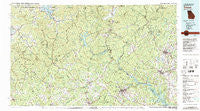
~ Toccoa GA topo map, 1:100000 scale, 30 X 60 Minute, Historical, 1981, updated 1982
Toccoa, Georgia, USGS topographic map dated 1981.
Includes geographic coordinates (latitude and longitude). This topographic map is suitable for hiking, camping, and exploring, or framing it as a wall map.
Printed on-demand using high resolution imagery, on heavy weight and acid free paper, or alternatively on a variety of synthetic materials.
Topos available on paper, Waterproof, Poly, or Tyvek. Usually shipping rolled, unless combined with other folded maps in one order.
- Product Number: USGS-5365126
- Free digital map download (high-resolution, GeoPDF): Toccoa, Georgia (file size: 30 MB)
- Map Size: please refer to the dimensions of the GeoPDF map above
- Weight (paper map): ca. 55 grams
- Map Type: POD USGS Topographic Map
- Map Series: HTMC
- Map Verison: Historical
- Cell ID: 68466
- Scan ID: 247663
- Imprint Year: 1982
- Woodland Tint: Yes
- Aerial Photo Year: 1977
- Edit Year: 1981
- Datum: NAD27
- Map Projection: Universal Transverse Mercator
- Map published by United States Geological Survey
- Map Language: English
- Scanner Resolution: 600 dpi
- Map Cell Name: Toccoa
- Grid size: 30 X 60 Minute
- Date on map: 1981
- Map Scale: 1:100000
- Geographical region: Georgia, United States
Neighboring Maps:
All neighboring USGS topo maps are available for sale online at a variety of scales.
Spatial coverage:
Topo map Toccoa, Georgia, covers the geographical area associated the following places:
- Pine Log Village - Antioch - Poplar Springs Ridge - Habersham - Friendship - Burton (historical) - Boydville - Russell (historical) - Ridgeland Estates - Batesville - Oculus (historical) - Fairplay Shores - Avalon - Avondale - Fairview - Dickerson Mill - Sautee - Colonial Heights - Beech Cove Vista - Clarkesville - Dixon Crossroads - Hunt (historical) - Hills - Springdale - Blairsville - Warne - New Switzerland - Tamassee - Anandale (historical) - Eastanollee - Soquee (historical) - Chauga Heights - Westminster - Youngstown - Ebenezer - Yonah - Conneross (historical) - Bert (historical) - Brasstown - Grace (historical) - Osborn - Mountain Scene - Willow (historical) - Jacksonville - Percival Crossroads - Tallulah Falls - Dixon Crossroads - Dahlonega - Kilby Mill - Gates (historical) - Cheohee - Laura (historical) - Quebec (historical) - Persimmon - Turnerville - Tate City - Harvest - Fairview - Hollywood - Spile - Stay (historical) - Town Creek - Five Points - Holly Springs - Hicks Store - Cornelia - Toccoa Falls - Titus - Clayton - Hood (historical) - Moody Cove - Canal Lake - Benefit - Cedar Cliff - South Union - Choestoe - Germany - Poplar Grove - Oakmont - Port Bass - Tesnatee - Tabor - Tugaloo - Burton Junction (historical) - Nacoochee - Caldwell (historical) - West Union - College Park - Townsend Mill - Toccoa - Johns Mill - Cleveland - Three Forks - Eastminster - Laurel Falls - Stovall Mill - Kinseytown - Sky Valley - Carnes Creek - Robertstown
- Map Area ID: AREA3534.5-84-83
- Northwest corner Lat/Long code: USGSNW35-84
- Northeast corner Lat/Long code: USGSNE35-83
- Southwest corner Lat/Long code: USGSSW34.5-84
- Southeast corner Lat/Long code: USGSSE34.5-83
- Northern map edge Latitude: 35
- Southern map edge Latitude: 34.5
- Western map edge Longitude: -84
- Eastern map edge Longitude: -83


