
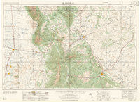
~ Trinidad CO topo map, 1:250000 scale, 1 X 2 Degree, Historical, 1958
Trinidad, Colorado, USGS topographic map dated 1958.
Includes geographic coordinates (latitude and longitude). This topographic map is suitable for hiking, camping, and exploring, or framing it as a wall map.
Printed on-demand using high resolution imagery, on heavy weight and acid free paper, or alternatively on a variety of synthetic materials.
Topos available on paper, Waterproof, Poly, or Tyvek. Usually shipping rolled, unless combined with other folded maps in one order.
- Product Number: USGS-5359849
- Free digital map download (high-resolution, GeoPDF): Trinidad, Colorado (file size: 13 MB)
- Map Size: please refer to the dimensions of the GeoPDF map above
- Weight (paper map): ca. 55 grams
- Map Type: POD USGS Topographic Map
- Map Series: HTMC
- Map Verison: Historical
- Cell ID: 69059
- Scan ID: 403205
- Woodland Tint: Yes
- Aerial Photo Year: 1954
- Field Check Year: 1954
- Datum: Unstated
- Map Projection: Transverse Mercator
- Map published by United States Army
- Map Language: English
- Scanner Resolution: 508 dpi
- Map Cell Name: Trinidad
- Grid size: 1 X 2 Degree
- Date on map: 1958
- Map Scale: 1:250000
- Geographical region: Colorado, United States
Neighboring Maps:
All neighboring USGS topo maps are available for sale online at a variety of scales.
Spatial coverage:
Topo map Trinidad, Colorado, covers the geographical area associated the following places:
- Hoehne - Mesita - Valdez - Monson - La Jara - Viola (historical) - Cedar Crest - Muleshoe - Cuerna Verde Park - Lynn - Fort Garland - Liberty - Reilly Canyon - Lasauses - Cuchara Junction - Delagua (historical) - Hartner - San Miguel - Madrid (historical) - Russell - Rugby - Mosca - Malachite - Rock Crossing - Delcarbon - Lobatos - Cokedale - Manassa - Eastdale - La Isla - Forbes (historical) - Farisita - Bountiful - Stonewall Gap - Walsenburg - Tyrone - Houghton - Cedarwood - Rouse - Maitland - Apache City - Bradford - Tioga - Velasquez Plaza - San Luis - San Acacio - Zamara - Romeo - Boncarbo - La Fruto - Colorado City - Estrella - Garland City (historical) - San Pablo - Rye - La Valley - Abeyta - Viejo San Acacio - Cuchara - Tijeras - Patterson Crossing - Cordova Plaza - Jaroso - Alamosa - Sarcillo - Red Wing - Ludlow - Whiterock - Garcia - Trinidad - Tercio - Engleville - San Isabel - La Veta Pass - Henry - Gulnare - Moffat - Barela - Pictou - Strong - Parras Plaza - Starkville - Piedmont (historical) - Lascar - Sopris Plaza (historical) - Fir - San Pedro - Weston - Jansen - Medina Plaza - Los Fuertes - Crestone - Gardner - Cottonwood - Torres - Occidental - Vallorso - Earl - Hooper - Monument Park
- Map Area ID: AREA3837-106-104
- Northwest corner Lat/Long code: USGSNW38-106
- Northeast corner Lat/Long code: USGSNE38-104
- Southwest corner Lat/Long code: USGSSW37-106
- Southeast corner Lat/Long code: USGSSE37-104
- Northern map edge Latitude: 38
- Southern map edge Latitude: 37
- Western map edge Longitude: -106
- Eastern map edge Longitude: -104


