
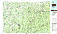
~ Warren PA topo map, 1:100000 scale, 30 X 60 Minute, Historical, 1983, updated 1984
Warren, Pennsylvania, USGS topographic map dated 1983.
Includes geographic coordinates (latitude and longitude). This topographic map is suitable for hiking, camping, and exploring, or framing it as a wall map.
Printed on-demand using high resolution imagery, on heavy weight and acid free paper, or alternatively on a variety of synthetic materials.
Topos available on paper, Waterproof, Poly, or Tyvek. Usually shipping rolled, unless combined with other folded maps in one order.
- Product Number: USGS-5332000
- Free digital map download (high-resolution, GeoPDF): Warren, Pennsylvania (file size: 25 MB)
- Map Size: please refer to the dimensions of the GeoPDF map above
- Weight (paper map): ca. 55 grams
- Map Type: POD USGS Topographic Map
- Map Series: HTMC
- Map Verison: Historical
- Cell ID: 68547
- Scan ID: 222391
- Imprint Year: 1984
- Woodland Tint: Yes
- Aerial Photo Year: 1981
- Edit Year: 1983
- Datum: NAD27
- Map Projection: Universal Transverse Mercator
- Map published by United States Geological Survey
- Map Language: English
- Scanner Resolution: 600 dpi
- Map Cell Name: Warren
- Grid size: 30 X 60 Minute
- Date on map: 1983
- Map Scale: 1:100000
- Geographical region: Pennsylvania, United States
Neighboring Maps:
All neighboring USGS topo maps are available for sale online at a variety of scales.
Spatial coverage:
Topo map Warren, Pennsylvania, covers the geographical area associated the following places:
- Sugar Grove - Teepleville - Minister - East Titusville - Pleasantville - Canadohta Lake - Warren - Five Points - Pioneer - East Hickory - Stoneham - Grunderville (historical) - Ferris Corners - Torpedo - Allegheny Springs - Guys Mills - Hastings - Cherrytree - Weldbank - Shipmans Eddy - Hazeltine Corners - Mayburg - Vrooman - Fagundus - Trunkeyville - Colza - Titusville - Endeavor - West Spring Creek - Lovell - Townville - Kellettville - Jackson Crossing - Rootville - Pineville - Selkirk - Stewart Run - Chapmanville - Kiser Corners - Bear Lake - Hearts Content - Wilson Mills - South Warren - Riceville - Enterprise - Millers Station - Hatchtown - Troy Center - Barnes - Ranges Corners - Pine Valley - Blue Jay - Little Cooley - Kimble Corners - Mill Village - Plum Corner - Fauncetown - Penoke - Rockdale Acres - Scandia - Tidioute - Mount Hope - Toonerville - Union City - Clarendon Heights - Tryonville - West Hickory - Scotts Crossing - East Wayne - Sunville - Putnamville - Iron City - Cherry Grove - Owltown - East Warren - Church Hill - East Shamburg - Kaneville - Neilltown - Little Hickory - Old Sheffield - Dotyville - Eldred Center - Akeley - Buchers Mills - Garland - Jamison - Gouldtown - Spring Creek - Black Ash - Milltown - Balltown - Fiddlergreen - Whig Hill - Lander - Sanford - Corry - Hermit Spring - Gresham - Dempseytown
- Map Area ID: AREA4241.5-80-79
- Northwest corner Lat/Long code: USGSNW42-80
- Northeast corner Lat/Long code: USGSNE42-79
- Southwest corner Lat/Long code: USGSSW41.5-80
- Southeast corner Lat/Long code: USGSSE41.5-79
- Northern map edge Latitude: 42
- Southern map edge Latitude: 41.5
- Western map edge Longitude: -80
- Eastern map edge Longitude: -79


