
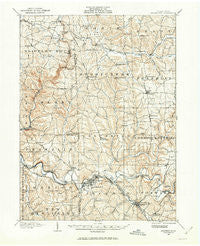
~ Zelienople PA topo map, 1:62500 scale, 15 X 15 Minute, Historical, 1908, updated 1963
Zelienople, Pennsylvania, USGS topographic map dated 1908.
Includes geographic coordinates (latitude and longitude). This topographic map is suitable for hiking, camping, and exploring, or framing it as a wall map.
Printed on-demand using high resolution imagery, on heavy weight and acid free paper, or alternatively on a variety of synthetic materials.
Topos available on paper, Waterproof, Poly, or Tyvek. Usually shipping rolled, unless combined with other folded maps in one order.
- Product Number: USGS-5331930
- Free digital map download (high-resolution, GeoPDF): Zelienople, Pennsylvania (file size: 9 MB)
- Map Size: please refer to the dimensions of the GeoPDF map above
- Weight (paper map): ca. 55 grams
- Map Type: POD USGS Topographic Map
- Map Series: HTMC
- Map Verison: Historical
- Cell ID: 64827
- Scan ID: 222647
- Imprint Year: 1963
- Survey Year: 1908
- Datum: NAD27
- Map Projection: Polyconic
- Map published by United States Geological Survey
- Map Language: English
- Scanner Resolution: 600 dpi
- Map Cell Name: Zenlienople
- Grid size: 15 X 15 Minute
- Date on map: 1908
- Map Scale: 1:62500
- Geographical region: Pennsylvania, United States
Neighboring Maps:
All neighboring USGS topo maps are available for sale online at a variety of scales.
Spatial coverage:
Topo map Zelienople, Pennsylvania, covers the geographical area associated the following places:
- Zeno - Kennedy Mill - Pleasant Hill - Goehring - Middle Lancaster - Harmony Junction - Petersville - Evans City - Old Furnace - Connoquenessing - Prospect - Lillyville - Wahlville - Buhls Station - Barrisville - Harmony - Brintons Corners - McConnells Mill - Whitestown - Hickory Corner - Lake Arthur Estates - Hazen - Fombell - Gibsondale - Pyles Mills - Nealeys - Eidenau - Portersville - Princeton - Celia - Shawwood Park - Grant City - Rose Point - Zelienople - Watters
- Map Area ID: AREA4140.75-80.25-80
- Northwest corner Lat/Long code: USGSNW41-80.25
- Northeast corner Lat/Long code: USGSNE41-80
- Southwest corner Lat/Long code: USGSSW40.75-80.25
- Southeast corner Lat/Long code: USGSSE40.75-80
- Northern map edge Latitude: 41
- Southern map edge Latitude: 40.75
- Western map edge Longitude: -80.25
- Eastern map edge Longitude: -80


