
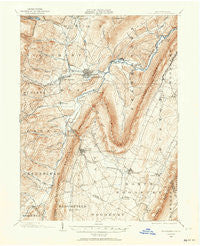
~ Hollidaysburg PA topo map, 1:62500 scale, 15 X 15 Minute, Historical, 1902, updated 1964
Hollidaysburg, Pennsylvania, USGS topographic map dated 1902.
Includes geographic coordinates (latitude and longitude). This topographic map is suitable for hiking, camping, and exploring, or framing it as a wall map.
Printed on-demand using high resolution imagery, on heavy weight and acid free paper, or alternatively on a variety of synthetic materials.
Topos available on paper, Waterproof, Poly, or Tyvek. Usually shipping rolled, unless combined with other folded maps in one order.
- Product Number: USGS-5330344
- Free digital map download (high-resolution, GeoPDF): Hollidaysburg, Pennsylvania (file size: 9 MB)
- Map Size: please refer to the dimensions of the GeoPDF map above
- Weight (paper map): ca. 55 grams
- Map Type: POD USGS Topographic Map
- Map Series: HTMC
- Map Verison: Historical
- Cell ID: 55385
- Scan ID: 171832
- Imprint Year: 1964
- Survey Year: 1902
- Datum: NAD27
- Map Projection: Polyconic
- Map published by United States Geological Survey
- Map Language: English
- Scanner Resolution: 600 dpi
- Map Cell Name: Hollidaysburg
- Grid size: 15 X 15 Minute
- Date on map: 1902
- Map Scale: 1:62500
- Geographical region: Pennsylvania, United States
Neighboring Maps:
All neighboring USGS topo maps are available for sale online at a variety of scales.
Spatial coverage:
Topo map Hollidaysburg, Pennsylvania, covers the geographical area associated the following places:
- Allegheny Furnace - Linds Crossing - Oreminea - Leamersville - Hileman Heights - Lakemont - Millerstown - Gaysport - Canoe Creek - Claysburg - Beryl - East Sharpsburg - South Altoona - Eldorado - Sunbrook - Reese - Clover Creek - Ore Hill - Henrietta - Coburn - Martinsburg Junction - Upper Reese - Canan - Royer - Sylvan Hills - Bakers Summit - Flowing Spring - Puzzletown - Stiffler - Clappertown - Sproul - Curryville - East Freedom - Hollidaysburg - Foot of Ten - McKee - Friesville - Vicksburg - Fort Fetter - Smith Corner - Martinsburg - Cotton Town - Loop - Reservoir - Newry - Geeseytown - Cross Keys - Horrell - Rodman - Duncansville - South Lakemont - Frankstown - Roaring Spring - Brooks Mill - Llyswen
- Map Area ID: AREA40.540.25-78.5-78.25
- Northwest corner Lat/Long code: USGSNW40.5-78.5
- Northeast corner Lat/Long code: USGSNE40.5-78.25
- Southwest corner Lat/Long code: USGSSW40.25-78.5
- Southeast corner Lat/Long code: USGSSE40.25-78.25
- Northern map edge Latitude: 40.5
- Southern map edge Latitude: 40.25
- Western map edge Longitude: -78.5
- Eastern map edge Longitude: -78.25


