
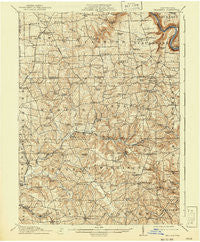
~ Hilliards PA topo map, 1:62500 scale, 15 X 15 Minute, Historical, 1912, updated 1941
Hilliards, Pennsylvania, USGS topographic map dated 1912.
Includes geographic coordinates (latitude and longitude). This topographic map is suitable for hiking, camping, and exploring, or framing it as a wall map.
Printed on-demand using high resolution imagery, on heavy weight and acid free paper, or alternatively on a variety of synthetic materials.
Topos available on paper, Waterproof, Poly, or Tyvek. Usually shipping rolled, unless combined with other folded maps in one order.
- Product Number: USGS-5330328
- Free digital map download (high-resolution, GeoPDF): Hilliards, Pennsylvania (file size: 9 MB)
- Map Size: please refer to the dimensions of the GeoPDF map above
- Weight (paper map): ca. 55 grams
- Map Type: POD USGS Topographic Map
- Map Series: HTMC
- Map Verison: Historical
- Cell ID: 55343
- Scan ID: 171821
- Imprint Year: 1941
- Survey Year: 1910
- Datum: NAD
- Map Projection: Polyconic
- Map published by United States Geological Survey
- Map Language: English
- Scanner Resolution: 600 dpi
- Map Cell Name: Hilliards
- Grid size: 15 X 15 Minute
- Date on map: 1912
- Map Scale: 1:62500
- Geographical region: Pennsylvania, United States
Neighboring Maps:
All neighboring USGS topo maps are available for sale online at a variety of scales.
Spatial coverage:
Topo map Hilliards, Pennsylvania, covers the geographical area associated the following places:
- Wick - North Washington - Rockland - Hallston - Five Points - Barkeyville - Deegan - Blacks - Higgins Corner - Nectarine - Branchton - Six Points - Boyers - Peaceful Valley - Bullion - Wesley - Cyrus - Crawford Corners - Murrinsville - Eakin Corner - De Sale - Bovard - Coaltown - Sandy Point - Smith Corners - Clintonville - Lisbon - Hilldale - Pine Grove - Parsonville - Whiskerville - Keenan - Walley Mill - West Sunbury - Cherry Valley - Argentine - Sherwin - Claytonia - Ferris - Humphreys Corner - Moniteau - Sedwicks Mill - Eau Claire - Kohlmeyer Corner - Atwells Crossing - Hilliards - Sutton Mill - Annisville - Annandale - Riddle Crossroads
- Map Area ID: AREA41.2541-80-79.75
- Northwest corner Lat/Long code: USGSNW41.25-80
- Northeast corner Lat/Long code: USGSNE41.25-79.75
- Southwest corner Lat/Long code: USGSSW41-80
- Southeast corner Lat/Long code: USGSSE41-79.75
- Northern map edge Latitude: 41.25
- Southern map edge Latitude: 41
- Western map edge Longitude: -80
- Eastern map edge Longitude: -79.75


