
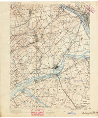
~ Burlington NJ topo map, 1:62500 scale, 15 X 15 Minute, Historical, 1890
Burlington, New Jersey, USGS topographic map dated 1890.
Includes geographic coordinates (latitude and longitude). This topographic map is suitable for hiking, camping, and exploring, or framing it as a wall map.
Printed on-demand using high resolution imagery, on heavy weight and acid free paper, or alternatively on a variety of synthetic materials.
Topos available on paper, Waterproof, Poly, or Tyvek. Usually shipping rolled, unless combined with other folded maps in one order.
- Product Number: USGS-5329542
- Free digital map download (high-resolution, GeoPDF): Burlington, New Jersey (file size: 6 MB)
- Map Size: please refer to the dimensions of the GeoPDF map above
- Weight (paper map): ca. 55 grams
- Map Type: POD USGS Topographic Map
- Map Series: HTMC
- Map Verison: Historical
- Cell ID: 51938
- Scan ID: 169832
- Survey Year: 1888
- Datum: Unstated
- Map Projection: Unstated
- Map published by United States Geological Survey
- Map Language: English
- Scanner Resolution: 600 dpi
- Map Cell Name: Burlington
- Grid size: 15 X 15 Minute
- Date on map: 1890
- Map Scale: 1:62500
- Geographical region: New Jersey, United States
Neighboring Maps:
All neighboring USGS topo maps are available for sale online at a variety of scales.
Spatial coverage:
Topo map Burlington, New Jersey, covers the geographical area associated the following places:
- Unionville - Neshaminy Hills - Red Cedar Hill - Jacksonville - Woodside - Vermilion Hill - La Trappe - Delaire Landing - Byberry - Edgewater Park - Scammells Corner - Riverside Park - Bristol Terrace Number Two - Parkland Heights - Levittown - Margo Gardens - Edgely - Parkwood Manor - Farnerville - Crabtree Hollow - Pennypacker Park - Millside Heights - Langhorne Manor - Garfield Park East - Bucktoe - West Bristol - Timbuctoo - Sharper - Eddington Park - Borton Landing - Idlewood - Willingboro - Fairview - Newportville - Midway - Grundys Corner - Fergusonville - Roelofs - Lakeside - Skin Corner - Plaza Park - Glendale - Villas of Middletown - Croydon Heights - Orchard View - Maple Beach - Riverside - Langhorne Gardens - Janney - Florence Station - Wheat Sheaf - Neshaminy (historical) - Twin Hill Park - Prospect Heights - Magnolia Hill - Town Estates - Kinkora - Maple Point - New Albany - Indian Creek - Will O Wood - Neshaminy Heights - Bridgetown - Normandy - Bath Addition - West Torresdale - Bridgetown - Millbrook Park - Whitewood - Dunlap - Hillcrest - Rancocas - Deacons - Delanco - Martins Beach - Yellowood - Springside - Croydon Acres - Echo Reach - Andalusia - Nottingham - Parkland - Morrell Park - Glen Ashton Farms - Violet Wood - Saint Leonard - Edge Hill - Prospect Park - Blue Ridge - Trevose Heights - Country Club Ridge - Calico Corner - Somerset Park - Stevens - Cooperstown - Fallsington - Holland - Cornwell - Cornwells Manor - Trevose
- Map Area ID: AREA40.2540-75-74.75
- Northwest corner Lat/Long code: USGSNW40.25-75
- Northeast corner Lat/Long code: USGSNE40.25-74.75
- Southwest corner Lat/Long code: USGSSW40-75
- Southeast corner Lat/Long code: USGSSE40-74.75
- Northern map edge Latitude: 40.25
- Southern map edge Latitude: 40
- Western map edge Longitude: -75
- Eastern map edge Longitude: -74.75


