
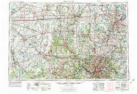
~ Cincinnati OH topo map, 1:250000 scale, 1 X 2 Degree, Historical, 1953, updated 1976
Cincinnati, Ohio, USGS topographic map dated 1953.
Includes geographic coordinates (latitude and longitude). This topographic map is suitable for hiking, camping, and exploring, or framing it as a wall map.
Printed on-demand using high resolution imagery, on heavy weight and acid free paper, or alternatively on a variety of synthetic materials.
Topos available on paper, Waterproof, Poly, or Tyvek. Usually shipping rolled, unless combined with other folded maps in one order.
- Product Number: USGS-5321566
- Free digital map download (high-resolution, GeoPDF): Cincinnati, Ohio (file size: 19 MB)
- Map Size: please refer to the dimensions of the GeoPDF map above
- Weight (paper map): ca. 55 grams
- Map Type: POD USGS Topographic Map
- Map Series: HTMC
- Map Verison: Historical
- Cell ID: 72224
- Scan ID: 224443
- Imprint Year: 1976
- Woodland Tint: Yes
- Aerial Photo Year: 1972
- Edit Year: 1974
- Field Check Year: 1953
- Datum: Unstated
- Map Projection: Transverse Mercator
- Map published by United States Geological Survey
- Map Language: English
- Scanner Resolution: 600 dpi
- Map Cell Name: Cincinnati
- Grid size: 1 X 2 Degree
- Date on map: 1953
- Map Scale: 1:250000
- Geographical region: Ohio, United States
Neighboring Maps:
All neighboring USGS topo maps are available for sale online at a variety of scales.
Spatial coverage:
Topo map Cincinnati, Ohio, covers the geographical area associated the following places:
- Knighthood Grove - Azalia - Rickard Acres - Dixiedale - County Line - Saint Peter - South Milford - Mount Healthy Heights - Kessler - New Salem - Colerain Heights - Sherman's Trailer Park - Peebles Corner - Harris City - Snow Hill - Tobasco - Crystal Lakes Mobile Home Park - Woodland Hills Mobile Home Park - Philadelphia - Hiser - Spring Grove Heights - Springersville - Montgomery - Oneida - Columbia Heights - Pekin - Clifton - Brent - Hartsville - Geist Woods - Remington - Millville - Day Heights - Ohmer Park - Greentree Corners - Middletown - Oldenburg - Corwin - Sunshine Mobile Home Park - Aurora - Lytle - Madisonville - Spyglass Hill - New Castle - Cumberland Ridge - Rohs Hill - Allen Crossing - Laura - Sugar Hills - Hopeville - Kitchener (historical) - Crescentville - Knarr Corner - Wittes Corners - Little Acre - Metamora - Ingomar - Elenor - Okeana - Luxhaven - Sunbury - Mudlick - O'Bryonsville - Oaklandon - Claysburg (historical) - Dayton - Garland - Otter Village - Cooper Corner - Tremont - Fort McKinley - Brookville - Pendleton - Hopeful Heights - New Marion - Liberty - Gwynneville - Regina Heights - Fairfield - Snidercrest - Bright - Millhousen - Middleboro - Lamme-Moraine Mobile Home Park - Hawthorn Hills - Locust Lake - Peoria - Loveland Park - Kings Mills - Alert - Fairwind Acres - Bunker Hill - Elizabethtown - Summerside Estates - Highland Park - Mount Harrison - New Lebanon Mobile Home Park - Milton - Oakland - Usrey Mobile Home Park
- Map Area ID: AREA4039-86-84
- Northwest corner Lat/Long code: USGSNW40-86
- Northeast corner Lat/Long code: USGSNE40-84
- Southwest corner Lat/Long code: USGSSW39-86
- Southeast corner Lat/Long code: USGSSE39-84
- Northern map edge Latitude: 40
- Southern map edge Latitude: 39
- Western map edge Longitude: -86
- Eastern map edge Longitude: -84


