
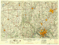
~ Cincinnati OH topo map, 1:250000 scale, 1 X 2 Degree, Historical, 1957
Cincinnati, Ohio, USGS topographic map dated 1957.
Includes geographic coordinates (latitude and longitude). This topographic map is suitable for hiking, camping, and exploring, or framing it as a wall map.
Printed on-demand using high resolution imagery, on heavy weight and acid free paper, or alternatively on a variety of synthetic materials.
Topos available on paper, Waterproof, Poly, or Tyvek. Usually shipping rolled, unless combined with other folded maps in one order.
- Product Number: USGS-5321564
- Free digital map download (high-resolution, GeoPDF): Cincinnati, Ohio (file size: 17 MB)
- Map Size: please refer to the dimensions of the GeoPDF map above
- Weight (paper map): ca. 55 grams
- Map Type: POD USGS Topographic Map
- Map Series: HTMC
- Map Verison: Historical
- Cell ID: 72224
- Scan ID: 224442
- Woodland Tint: Yes
- Aerial Photo Year: 1952
- Field Check Year: 1953
- Datum: Unstated
- Map Projection: Transverse Mercator
- Map published by United States Army Corps of Engineers
- Map published by United States Army
- Map Language: English
- Scanner Resolution: 600 dpi
- Map Cell Name: Cincinnati
- Grid size: 1 X 2 Degree
- Date on map: 1957
- Map Scale: 1:250000
- Geographical region: Ohio, United States
Neighboring Maps:
All neighboring USGS topo maps are available for sale online at a variety of scales.
Spatial coverage:
Topo map Cincinnati, Ohio, covers the geographical area associated the following places:
- Eileen Gardens - California - Knollwood - New Lexington - Country Club Acres - Augusta Hills - Reds Corner - New Fairfield - Whites Corner - Cheviot - Peters Switch - Sixteen Mile Stand - Senior - Clearview - Fairfax - Bowling Trailer Park - Country Club Highlands - Fairborn - Clifford - Oakwood Village - Maurice - Nulltown - Enterprise - Peoria - Woodville - Sunview - Dunlapsville - Trotwood - Clifton - Mount Airy - Miamiville - Camp Springs - Miami Grove - Cyclorama Heights - Blue Jay - Okeana - Whitfield - Dabney - Brooks Crossing - Hill Top Acres - Waynesville - Guilford - Wardwood Acres - Eightmile - Rialto - New Palestine - Chester - Hopkinsville - Pleasant View - Grant City - Palestine - Oakdale - Lake View - Bucks Creek - Henderson - Kyle - Cuba - Fairview - Emery Acres - Camp Washington - Fenns - West Elkton - Pleasant Plain - Knighthood Village - New Burlington - Ithaca - Hamburg - Blue Ash - North Gate - Auburn - Willow Branch - Schildmeier Park - West Chester Woods - Oaklandon - Sandstone Ridge - Southern Hills - Woodland Park - Woodland Hills Mobile Home Park - Behlmer Corner - McCoy - Skyline Acres - Park Layne - West Price Hill - Astoria - Youngs Corner - Enochsburg - Gem City Estates - Reily - Ideal Mobile Home Park - South Highlands - Oakdale - Landen - Northridge - Rolling Knolls - Carrollton - Miami Shores - Lantana Estate - Modest - Edgemont - Crystal Lakes Mobile Home Park
- Map Area ID: AREA4039-86-84
- Northwest corner Lat/Long code: USGSNW40-86
- Northeast corner Lat/Long code: USGSNE40-84
- Southwest corner Lat/Long code: USGSSW39-86
- Southeast corner Lat/Long code: USGSSE39-84
- Northern map edge Latitude: 40
- Southern map edge Latitude: 39
- Western map edge Longitude: -86
- Eastern map edge Longitude: -84


