
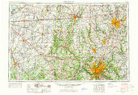
~ Cincinnati OH topo map, 1:250000 scale, 1 X 2 Degree, Historical, 1953, updated 1965
Cincinnati, Ohio, USGS topographic map dated 1953.
Includes geographic coordinates (latitude and longitude). This topographic map is suitable for hiking, camping, and exploring, or framing it as a wall map.
Printed on-demand using high resolution imagery, on heavy weight and acid free paper, or alternatively on a variety of synthetic materials.
Topos available on paper, Waterproof, Poly, or Tyvek. Usually shipping rolled, unless combined with other folded maps in one order.
- Product Number: USGS-5321562
- Free digital map download (high-resolution, GeoPDF): Cincinnati, Ohio (file size: 17 MB)
- Map Size: please refer to the dimensions of the GeoPDF map above
- Weight (paper map): ca. 55 grams
- Map Type: POD USGS Topographic Map
- Map Series: HTMC
- Map Verison: Historical
- Cell ID: 72224
- Scan ID: 224441
- Imprint Year: 1965
- Woodland Tint: Yes
- Edit Year: 1964
- Field Check Year: 1953
- Datum: Unstated
- Map Projection: Transverse Mercator
- Map published by United States Geological Survey
- Map Language: English
- Scanner Resolution: 600 dpi
- Map Cell Name: Cincinnati
- Grid size: 1 X 2 Degree
- Date on map: 1953
- Map Scale: 1:250000
- Geographical region: Ohio, United States
Neighboring Maps:
All neighboring USGS topo maps are available for sale online at a variety of scales.
Spatial coverage:
Topo map Cincinnati, Ohio, covers the geographical area associated the following places:
- Crosswinds At Windermere - Huber Mobile Home Park - Tylersville - Shawnee Mobile Home Court - Prospect Hill - Waterloo - West Manchester - Logan - Dry Run - Red Bank - Holiday Acres - Werk Place - Womacks Mobile Home Park - Simms (historical) - Barwyn Acres - Park Hills - Clinton - Fairway Terrace Mobile Home Park - Mount Auburn - Mount Healthy - Carmonte - Five Points - Alpha - Montgomery Heights - Alert - Queensville - Riverside - Harmony Mobile Home Park - Indian Creek Estates - Warwickshire - Kenridge - Dover - Cuba - Monterey - Castlewood Trailer Court - New Burlington - Ransom - Salem Heights - Clough Heights - Highland Park - Saint Peter - Oaklandon - Knightstown - Belmont - Crown Point - Bromley - Schenck - Rockdale - Glen Abbey At Windermere - Bridgeport - Anderson Ferry - Ninemile - Norristown - Hardinsburg - New Salem - Sparta - Taylorsburg - New Chicago - Forest Hills Estates - McCoy - Latonia Terrace - Blue Ash - West Price Hill - Wrights Corner - The Woods - South Highlands - Lemon - Mount Sinai - Keenan Avenue Mobile Home Park - Taylors Creek - Woodlawn - Hartsville - Glendale - Forest Hill - Wyoming Meadows - Riverview Acres - Oak Tree Crossroads - Helmcrest - Withamsville - Winston Park - Centerville - Country Acres - Far Hills - Catalpa Grove Mobile Home Park - Harveysburg - West Milton - Wintondale - Otter Village - Morris - Saint Charles - Idlewold - Erlanger - Walnut Hills - Irvington - Brentwood - Mohawk - Oakdale - Springhill (historical) - Homer - Rossmoyne
- Map Area ID: AREA4039-86-84
- Northwest corner Lat/Long code: USGSNW40-86
- Northeast corner Lat/Long code: USGSNE40-84
- Southwest corner Lat/Long code: USGSSW39-86
- Southeast corner Lat/Long code: USGSSE39-84
- Northern map edge Latitude: 40
- Southern map edge Latitude: 39
- Western map edge Longitude: -86
- Eastern map edge Longitude: -84


