
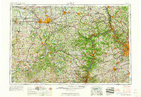
~ Canton OH topo map, 1:250000 scale, 1 X 2 Degree, Historical, 1962
Canton, Ohio, USGS topographic map dated 1962.
Includes geographic coordinates (latitude and longitude). This topographic map is suitable for hiking, camping, and exploring, or framing it as a wall map.
Printed on-demand using high resolution imagery, on heavy weight and acid free paper, or alternatively on a variety of synthetic materials.
Topos available on paper, Waterproof, Poly, or Tyvek. Usually shipping rolled, unless combined with other folded maps in one order.
- Product Number: USGS-5321558
- Free digital map download (high-resolution, GeoPDF): Canton, Ohio (file size: 22 MB)
- Map Size: please refer to the dimensions of the GeoPDF map above
- Weight (paper map): ca. 55 grams
- Map Type: POD USGS Topographic Map
- Map Series: HTMC
- Map Verison: Historical
- Cell ID: 68700
- Scan ID: 224318
- Woodland Tint: Yes
- Visual Version Number: 2
- Field Check Year: 1957
- Datum: Unstated
- Map Projection: Transverse Mercator
- Map published by United States Geological Survey
- Map Language: English
- Scanner Resolution: 600 dpi
- Map Cell Name: Canton
- Grid size: 1 X 2 Degree
- Date on map: 1962
- Map Scale: 1:250000
- Geographical region: Ohio, United States
Neighboring Maps:
All neighboring USGS topo maps are available for sale online at a variety of scales.
Spatial coverage:
Topo map Canton, Ohio, covers the geographical area associated the following places:
- Sparta - New Cumberland - Millville - Beechmont - Mayfair East - Loomis - Skit - Hickory Corner - Oakmont Hills - Leewood Park - Oak Manor - Boden - Robinwood Estates - Olszeski Town - Forest View Mobile Home Park - Cassville - Connor - Elizabethtown - Westview Mobile Home Park - Coketown - Morristown - Maurer Trailer Park - Dover - Willow Grove - Emsworth - Scottsville - Greenwood Commons - Butler Mobile City - Candor - Melody Mobile Home Park - Cambridge - Mechanicsburg - Massillon - Charleston Place - West Library - New England (historical) - Villages At Meadow Wood - Jimtown - Browns Heights - Woodsdale - Mount Herman - Wolfes Mobile Home Park - Cassell - Winfield - Wooster Rolling Wheels - Blackband - Sandy Beach Trailer Park - Green - Hills and Dales - Canonsburg - Ambridge - Wallace City - Elm Grove - Leetsdale - Follansbee - Skyline Hills - Sunnymeade - Warrentown - Forestwood - New Brighton - Port Homer - Hopedale - Moninger - McQuaid (historical) - Mineral City - Cadiz Junction - Avella Highlands - Wolfhurst - Scenery Hill - Bower Hill - Deandale - Farr Hill Mobile Home Park - Fishersville - Roneys Point - Meadow Village - Station 15 - Weilersville - North Wheeling - Dutch Corners - Vineyard Hills - Jackson - Steubenville - Fiat - Beadling - Meadow Lands - Locust Grove - Reading - Gilkeson - Chester - Lake Sherman Village - Eckley - Hillcrest Highlands - West Alexander - Bridgewater - Bakersville - Hopewell - Hackney - Kimbolton - Greggsville - Hoytdale
- Map Area ID: AREA4140-82-80
- Northwest corner Lat/Long code: USGSNW41-82
- Northeast corner Lat/Long code: USGSNE41-80
- Southwest corner Lat/Long code: USGSSW40-82
- Southeast corner Lat/Long code: USGSSE40-80
- Northern map edge Latitude: 41
- Southern map edge Latitude: 40
- Western map edge Longitude: -82
- Eastern map edge Longitude: -80


