
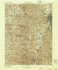
~ Zanesville OH topo map, 1:62500 scale, 15 X 15 Minute, Historical, 1910, updated 1939
Zanesville, Ohio, USGS topographic map dated 1910.
Includes geographic coordinates (latitude and longitude). This topographic map is suitable for hiking, camping, and exploring, or framing it as a wall map.
Printed on-demand using high resolution imagery, on heavy weight and acid free paper, or alternatively on a variety of synthetic materials.
Topos available on paper, Waterproof, Poly, or Tyvek. Usually shipping rolled, unless combined with other folded maps in one order.
- Product Number: USGS-5321454
- Free digital map download (high-resolution, GeoPDF): Zanesville, Ohio (file size: 11 MB)
- Map Size: please refer to the dimensions of the GeoPDF map above
- Weight (paper map): ca. 55 grams
- Map Type: POD USGS Topographic Map
- Map Series: HTMC
- Map Verison: Historical
- Cell ID: 64822
- Scan ID: 226490
- Imprint Year: 1939
- Survey Year: 1908
- Datum: Unstated
- Map Projection: Polyconic
- Map published by United States Geological Survey
- Map Language: English
- Scanner Resolution: 600 dpi
- Map Cell Name: Zanesville
- Grid size: 15 X 15 Minute
- Date on map: 1910
- Map Scale: 1:62500
- Geographical region: Ohio, United States
Neighboring Maps:
All neighboring USGS topo maps are available for sale online at a variety of scales.
Spatial coverage:
Topo map Zanesville, Ohio, covers the geographical area associated the following places:
- Redfield - Mount Perry - Southern Hills - Darlington - Roberts (historical) - Westwood - Meadowbrook - Brigglesville - Horne (historical) - Meadow Farm - Gratiot - Terrace - Muskingum (historical) - Hopewell - Zanesville - Wesley - Fultonham - Avondale - Northwood - Saltillo - Zanesville Terrace - South Zanesville - Wesley - East Fultonham - Harding Heights - Avalon Heights - Sego - Cannon - Elizabeth - Olde Falls Village - Moxahala Park - Roberts - Putnam - White Cottage - Opera (historical) - West Zanesville - Ironspot - Mount Sterling - Russells - Brighton - Conway Addition - Fairview - Dillon View - Lewis (historical) - Licking View - Dillon Falls - Roseville - North Zanesville - Crooksville - Maysville - Clover Hill - Laurel Ridge - Pine Ridge
- Map Area ID: AREA4039.75-82.25-82
- Northwest corner Lat/Long code: USGSNW40-82.25
- Northeast corner Lat/Long code: USGSNE40-82
- Southwest corner Lat/Long code: USGSSW39.75-82.25
- Southeast corner Lat/Long code: USGSSE39.75-82
- Northern map edge Latitude: 40
- Southern map edge Latitude: 39.75
- Western map edge Longitude: -82.25
- Eastern map edge Longitude: -82


