
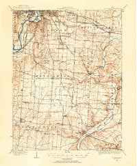
~ Waynesville OH topo map, 1:62500 scale, 15 X 15 Minute, Historical, 1913
Waynesville, Ohio, USGS topographic map dated 1913.
Includes geographic coordinates (latitude and longitude). This topographic map is suitable for hiking, camping, and exploring, or framing it as a wall map.
Printed on-demand using high resolution imagery, on heavy weight and acid free paper, or alternatively on a variety of synthetic materials.
Topos available on paper, Waterproof, Poly, or Tyvek. Usually shipping rolled, unless combined with other folded maps in one order.
- Product Number: USGS-5321388
- Free digital map download (high-resolution, GeoPDF): Waynesville, Ohio (file size: 7 MB)
- Map Size: please refer to the dimensions of the GeoPDF map above
- Weight (paper map): ca. 55 grams
- Map Type: POD USGS Topographic Map
- Map Series: HTMC
- Map Verison: Historical
- Cell ID: 64334
- Scan ID: 226520
- Survey Year: 1913
- Datum: Unstated
- Map Projection: Polyconic
- Map published by United States Geological Survey
- Map Language: English
- Scanner Resolution: 600 dpi
- Map Cell Name: Waynesville
- Grid size: 15 X 15 Minute
- Date on map: 1913
- Map Scale: 1:62500
- Geographical region: Ohio, United States
Neighboring Maps:
All neighboring USGS topo maps are available for sale online at a variety of scales.
Spatial coverage:
Topo map Waynesville, Ohio, covers the geographical area associated the following places:
- Royal Springs Estates - Carmonte - Valleywood - Greenmont - Crosswick - Clement - Centerville - Waynesville - Ridgeville - Lytle - Hampstead - Manor (historical) - Shakertown - Springboro - Spring Valley - Dwyer - Wittes Corners - Belmont - Patterson - Harmony Mobile Home Park - South Dale - Kitchener (historical) - Venable (historical) - Five Points - West Side - Gem City Estates - Kettering - Berkley Heights - Beavercreek - Spring Valley Estates - American Trailer Park - Miami Shores - Short Hills - Far Hills - Beavertown - Pekin - Washington Mills - Walnut Hills - Flat Iron - Ohmer Park - Tamarack Hills - Oakwood Village - Cains Mobile Home Park - Bellbrook - Ferry - Woodbourne - Hide A Way Mobile Home Park - Shook's Riverside Mobile Home Park - Shanersville - Oakdale - Moraine - Circle Z Mobile Home Park - Alpha - Corwin - Harveysburg - Lindenhall - Pasadena - Edgemont - Kenricksville - Oakwood - Mount Holly - Linda's Web Mobile Home Park - Oakland - Zimmerman - Edgewood (historical) - Knollwood - Lamme-Moraine Mobile Home Park - Southern Hills - Mount Saint John - Roxanna - Hearthstone - Oak Ridge - Whites Corner
- Map Area ID: AREA39.7539.5-84.25-84
- Northwest corner Lat/Long code: USGSNW39.75-84.25
- Northeast corner Lat/Long code: USGSNE39.75-84
- Southwest corner Lat/Long code: USGSSW39.5-84.25
- Southeast corner Lat/Long code: USGSSE39.5-84
- Northern map edge Latitude: 39.75
- Southern map edge Latitude: 39.5
- Western map edge Longitude: -84.25
- Eastern map edge Longitude: -84


