
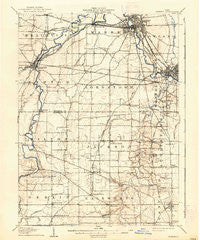
~ Warren OH topo map, 1:62500 scale, 15 X 15 Minute, Historical, 1908, updated 1937
Warren, Ohio, USGS topographic map dated 1908.
Includes geographic coordinates (latitude and longitude). This topographic map is suitable for hiking, camping, and exploring, or framing it as a wall map.
Printed on-demand using high resolution imagery, on heavy weight and acid free paper, or alternatively on a variety of synthetic materials.
Topos available on paper, Waterproof, Poly, or Tyvek. Usually shipping rolled, unless combined with other folded maps in one order.
- Product Number: USGS-5321372
- Free digital map download (high-resolution, GeoPDF): Warren, Ohio (file size: 6 MB)
- Map Size: please refer to the dimensions of the GeoPDF map above
- Weight (paper map): ca. 55 grams
- Map Type: POD USGS Topographic Map
- Map Series: HTMC
- Map Verison: Historical
- Cell ID: 64242
- Scan ID: 226707
- Imprint Year: 1937
- Survey Year: 1906
- Datum: Unstated
- Map Projection: Polyconic
- Map published by United States Geological Survey
- Map Language: English
- Scanner Resolution: 600 dpi
- Map Cell Name: Warren
- Grid size: 15 X 15 Minute
- Date on map: 1908
- Map Scale: 1:62500
- Geographical region: Ohio, United States
Neighboring Maps:
All neighboring USGS topo maps are available for sale online at a variety of scales.
Spatial coverage:
Topo map Warren, Ohio, covers the geographical area associated the following places:
- Mineral Ridge - Shively Corners - Trumbull Homes - Niles Junction - South Canal - Braceville Ridge - DeForest Junction - Herbert Corners - Somerset 45 Manor - Lake Milton Mobile Home Park - North Jackson - Brentwood Mobile Home Park - Geeburg - Ohlton (historical) - Camp Park - Bolindale - Craig Beach - Lake Milton - Lordstown - Rosemont - Niles - Taylor Corners - Shepard's Mobile Home Park - Austintown - Arhaven Estates - Newton Heights - Soaptown - Riverview - Center World - Austin Village - Shillings Mill - Lake Park Estates - Duck Creek - Misner Corners - Rays Corners - Berlin Center - Canyon Park - Dublin - Smith Corners - DeForest - Villager Mobile Home Park - Buckeye Mobile Home Park - West River Park - Westhill Heights - Sunset Beach - Blanco - Blue Water Manor - South Niles - Ohltown - West Austintown - Arlington Heights - Stony Ridge - Tiger - Leavittsburg - Pricetown - Braceville - Imperial Mobile Home Park - Warren - Newton Falls - Fredericksburg - Ellsworth - Westwood Lake Park - Maderite Heights - Shiltown - West View - Canfield - Oak Hill Mobile Home Park - Evansville - Rose Park
- Map Area ID: AREA41.2541-81-80.75
- Northwest corner Lat/Long code: USGSNW41.25-81
- Northeast corner Lat/Long code: USGSNE41.25-80.75
- Southwest corner Lat/Long code: USGSSW41-81
- Southeast corner Lat/Long code: USGSSE41-80.75
- Northern map edge Latitude: 41.25
- Southern map edge Latitude: 41
- Western map edge Longitude: -81
- Eastern map edge Longitude: -80.75


