
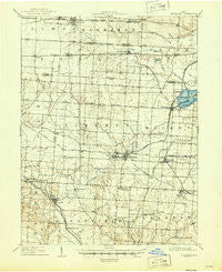
~ Thurston OH topo map, 1:62500 scale, 15 X 15 Minute, Historical, 1909, updated 1946
Thurston, Ohio, USGS topographic map dated 1909.
Includes geographic coordinates (latitude and longitude). This topographic map is suitable for hiking, camping, and exploring, or framing it as a wall map.
Printed on-demand using high resolution imagery, on heavy weight and acid free paper, or alternatively on a variety of synthetic materials.
Topos available on paper, Waterproof, Poly, or Tyvek. Usually shipping rolled, unless combined with other folded maps in one order.
- Product Number: USGS-5321346
- Free digital map download (high-resolution, GeoPDF): Thurston, Ohio (file size: 6 MB)
- Map Size: please refer to the dimensions of the GeoPDF map above
- Weight (paper map): ca. 55 grams
- Map Type: POD USGS Topographic Map
- Map Series: HTMC
- Map Verison: Historical
- Cell ID: 63552
- Scan ID: 226774
- Imprint Year: 1946
- Survey Year: 1907
- Datum: NAD
- Map Projection: Polyconic
- Map published by United States Geological Survey
- Map Language: English
- Scanner Resolution: 600 dpi
- Map Cell Name: Thurston
- Grid size: 15 X 15 Minute
- Date on map: 1909
- Map Scale: 1:62500
- Geographical region: Ohio, United States
Neighboring Maps:
All neighboring USGS topo maps are available for sale online at a variety of scales.
Spatial coverage:
Topo map Thurston, Ohio, covers the geographical area associated the following places:
- Lockville - Har-Win Acres - Pataskala - Havensport - Millersport - Lakeside - Happy Homes - East Millersport - Summerland Beach - Kellers Court - Lockville Station - Beals - Carroll - Kirkersville - Canyon Villa Estates - Chevington Woods North - Sandstone Canyon - Stoudertown - Thurston - Columbia Center - Wagram - Pinecrest Estates - Etna - Hollywood by the Lake - Sunshine Park - Dumontville - Outville - Wooded Hills - Jefferson Woods - Harley - Monticello (historical) - Baltimore - Luray - Pleasantville
- Map Area ID: AREA4039.75-82.75-82.5
- Northwest corner Lat/Long code: USGSNW40-82.75
- Northeast corner Lat/Long code: USGSNE40-82.5
- Southwest corner Lat/Long code: USGSSW39.75-82.75
- Southeast corner Lat/Long code: USGSSE39.75-82.5
- Northern map edge Latitude: 40
- Southern map edge Latitude: 39.75
- Western map edge Longitude: -82.75
- Eastern map edge Longitude: -82.5


