
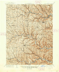
~ St Clairsville OH topo map, 1:62500 scale, 15 X 15 Minute, Historical, 1905, updated 1948
St Clairsville, Ohio, USGS topographic map dated 1905.
Includes geographic coordinates (latitude and longitude). This topographic map is suitable for hiking, camping, and exploring, or framing it as a wall map.
Printed on-demand using high resolution imagery, on heavy weight and acid free paper, or alternatively on a variety of synthetic materials.
Topos available on paper, Waterproof, Poly, or Tyvek. Usually shipping rolled, unless combined with other folded maps in one order.
- Product Number: USGS-5321318
- Free digital map download (high-resolution, GeoPDF): St Clairsville, Ohio (file size: 10 MB)
- Map Size: please refer to the dimensions of the GeoPDF map above
- Weight (paper map): ca. 55 grams
- Map Type: POD USGS Topographic Map
- Map Series: HTMC
- Map Verison: Historical
- Cell ID: 52619
- Scan ID: 227273
- Imprint Year: 1948
- Survey Year: 1903
- Datum: NAD
- Map Projection: Polyconic
- Map published by United States Geological Survey
- Map Language: English
- Scanner Resolution: 600 dpi
- Map Cell Name: Clairsville
- Grid size: 15 X 15 Minute
- Date on map: 1905
- Map Scale: 1:62500
- Geographical region: Ohio, United States
Neighboring Maps:
All neighboring USGS topo maps are available for sale online at a variety of scales.
Spatial coverage:
Topo map St Clairsville, Ohio, covers the geographical area associated the following places:
- Shepherdstown - Startle (historical) - Great Western - Emerson - Crabapple - Morningview - Horton - Olszeski Town - Fairpoint - Dunglen - Wheeling Valley (historical) - Stidds Trailer Court - Ramsey - Highland Terrace - Adena - Ginther (historical) - Pleasant Grove - Blaine - Claremont - Saint Clairsville - Duncanwood - Pine Valley - Barton - Whitney - Dillonvale - Hammond Crossroad - Newtown (historical) - Kinsman - Crescent - Lloydsville - Echo - Science Hill - Deyarmonville - Blainesville - Midway - Hagan Addition - Hurford - Chickwan - Maynard - Highland Terrace - East Richland - Belleve - Long Run - Colerain - Oco - Georgetown - Stewartsville - Glencoe - Herrick - Bannock - Wolfhurst - Blairmont - Harrisville - Belknap - McClainville - Lamira - Neffs - Warnock - Lansing - Provident - Bradley - Wheeling Creek - New Athens - Homeside - Uniontown - Saint Joe - Donnersville - Farmington - Mount Pleasant - Sunset Heights - Boydsville - Robyville - Presidential Estates - Brookside
- Map Area ID: AREA40.2540-81-80.75
- Northwest corner Lat/Long code: USGSNW40.25-81
- Northeast corner Lat/Long code: USGSNE40.25-80.75
- Southwest corner Lat/Long code: USGSSW40-81
- Southeast corner Lat/Long code: USGSSE40-80.75
- Northern map edge Latitude: 40.25
- Southern map edge Latitude: 40
- Western map edge Longitude: -81
- Eastern map edge Longitude: -80.75


