
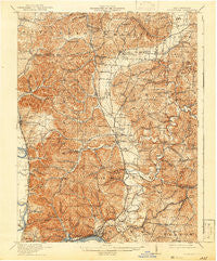
~ Sciotoville OH topo map, 1:62500 scale, 15 X 15 Minute, Historical, 1913, updated 1942
Sciotoville, Ohio, USGS topographic map dated 1913.
Includes geographic coordinates (latitude and longitude). This topographic map is suitable for hiking, camping, and exploring, or framing it as a wall map.
Printed on-demand using high resolution imagery, on heavy weight and acid free paper, or alternatively on a variety of synthetic materials.
Topos available on paper, Waterproof, Poly, or Tyvek. Usually shipping rolled, unless combined with other folded maps in one order.
- Product Number: USGS-5321278
- Free digital map download (high-resolution, GeoPDF): Sciotoville, Ohio (file size: 11 MB)
- Map Size: please refer to the dimensions of the GeoPDF map above
- Weight (paper map): ca. 55 grams
- Map Type: POD USGS Topographic Map
- Map Series: HTMC
- Map Verison: Historical
- Cell ID: 62203
- Scan ID: 226934
- Imprint Year: 1942
- Survey Year: 1911
- Datum: NAD
- Map Projection: Polyconic
- Map published by United States Geological Survey
- Map Language: English
- Scanner Resolution: 600 dpi
- Map Cell Name: Sciotoville
- Grid size: 15 X 15 Minute
- Date on map: 1913
- Map Scale: 1:62500
- Geographical region: Ohio, United States
Neighboring Maps:
All neighboring USGS topo maps are available for sale online at a variety of scales.
Spatial coverage:
Topo map Sciotoville, Ohio, covers the geographical area associated the following places:
- Pinkerman - Eden Park - Wheelers Mill - Portsmouth Mobile Home Park - Massie (historical) - Tomlison Addition - Wallace Mills - Clarktown - New Boston - North Moreland - Stockdale - Sciotodale - Camp Bennett - Highland Bend - Rubyville - Perry Addition - Egypt - Harrison Furnace - Minford - Frederick - Sciotoville - Slocum Heights - East Portsmouth (historical) - Colony Mobile Home Park - Ashley Corner - Edmunds Switch - Fair Oaks - Harrison Mills - Happy Hours Addition - Purdy Corners - Lucasville - Modern Mobile Home Park - Twin Valley - Scioto Furnace - Slocum - Preston Addition - Cockrell Run - Rosemount - Vera Junction - Rigrish Addition - Gephart
- Map Area ID: AREA3938.75-83-82.75
- Northwest corner Lat/Long code: USGSNW39-83
- Northeast corner Lat/Long code: USGSNE39-82.75
- Southwest corner Lat/Long code: USGSSW38.75-83
- Southeast corner Lat/Long code: USGSSE38.75-82.75
- Northern map edge Latitude: 39
- Southern map edge Latitude: 38.75
- Western map edge Longitude: -83
- Eastern map edge Longitude: -82.75


