
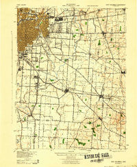
~ East Columbus OH topo map, 1:62500 scale, 15 X 15 Minute, Historical, 1943
East Columbus, Ohio, USGS topographic map dated 1943.
Includes geographic coordinates (latitude and longitude). This topographic map is suitable for hiking, camping, and exploring, or framing it as a wall map.
Printed on-demand using high resolution imagery, on heavy weight and acid free paper, or alternatively on a variety of synthetic materials.
Topos available on paper, Waterproof, Poly, or Tyvek. Usually shipping rolled, unless combined with other folded maps in one order.
- Product Number: USGS-5320870
- Free digital map download (high-resolution, GeoPDF): East Columbus, Ohio (file size: 6 MB)
- Map Size: please refer to the dimensions of the GeoPDF map above
- Weight (paper map): ca. 55 grams
- Map Type: POD USGS Topographic Map
- Map Series: HTMC
- Map Verison: Historical
- Cell ID: 53689
- Scan ID: 224952
- Woodland Tint: Yes
- Aerial Photo Year: 1940
- Datum: NAD
- Map Projection: Polyconic
- Map published by United States Army Corps of Engineers
- Map published by United States Department of War
- Map Language: English
- Scanner Resolution: 600 dpi
- Map Cell Name: East Columbus
- Grid size: 15 X 15 Minute
- Date on map: 1943
- Map Scale: 1:62500
- Geographical region: Ohio, United States
Neighboring Maps:
All neighboring USGS topo maps are available for sale online at a variety of scales.
Spatial coverage:
Topo map East Columbus, Ohio, covers the geographical area associated the following places:
- Valley Crossing - Abbie Trails - Bedford Place - Blacklick Estates - Blacklick Ridge - Villas At Charleston Lake - Lithopolis - Pickerington - Obetz - Marcy - Milo - Crawford Farms - Lehman Meadows - Sharp (historical) - Taylor Station - Greensview Villas - Brookside Park - Whitehall - Winchester Lakes - Slate Ridge Estates - Brice Meadows - Blacklick - Bixford Green - Eastmoor - White Oak Park - Bannon - Briarcliff - Rose Hill Heights - Winchester Park Addition - Brice - Stonehill - Gender Park - Zimmer - Lehman Estates - Canal Winchester - Beckley Addition - Cobbleton Grove - Kingswood Farms - Chelsea Glen - Edward - Doneys (historical) - Waterloo - Washington Knoll - Village At Shannon Green - Waggoner Woods - Hamilton Meadows - Lockbourne - Munks Corners - Reynoldsburg - Waggoner Park - Bright (historical) - Winchester Highlands - Essex Place - Meadows At Winchester - Dorchester Green - Slough - Jefferson - Woodstream - The Villages At Winchester - Longwood - Hanford - Steelton - East Columbus - Lombardy Heights - Columbus - Greencastle - Village At Schirm Farms - Big Walnut (historical) - Roseland - Groveport - Shepard - Countryview Village - Kensington Glen - Bexley - Reese - Truro - Motts Place - Duvall - Winchester Trace - Hummell Grove - Cedar Creek - Summit Station - Chester Heights - Edgewater Park - Fairfield Farms - Kramers Addition - Idlewood Manor
- Map Area ID: AREA4039.75-83-82.75
- Northwest corner Lat/Long code: USGSNW40-83
- Northeast corner Lat/Long code: USGSNE40-82.75
- Southwest corner Lat/Long code: USGSSW39.75-83
- Southeast corner Lat/Long code: USGSSE39.75-82.75
- Northern map edge Latitude: 40
- Southern map edge Latitude: 39.75
- Western map edge Longitude: -83
- Eastern map edge Longitude: -82.75


