
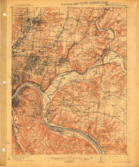
~ East Cincinnati OH topo map, 1:62500 scale, 15 X 15 Minute, Historical, 1914
East Cincinnati, Ohio, USGS topographic map dated 1914.
Includes geographic coordinates (latitude and longitude). This topographic map is suitable for hiking, camping, and exploring, or framing it as a wall map.
Printed on-demand using high resolution imagery, on heavy weight and acid free paper, or alternatively on a variety of synthetic materials.
Topos available on paper, Waterproof, Poly, or Tyvek. Usually shipping rolled, unless combined with other folded maps in one order.
- Product Number: USGS-5320866
- Free digital map download (high-resolution, GeoPDF): East Cincinnati, Ohio (file size: 7 MB)
- Map Size: please refer to the dimensions of the GeoPDF map above
- Weight (paper map): ca. 55 grams
- Map Type: POD USGS Topographic Map
- Map Series: HTMC
- Map Verison: Historical
- Cell ID: 53688
- Scan ID: 708568
- Survey Year: 1898
- Datum: Unstated
- Map Projection: Unstated
- Map published by United States Geological Survey
- Map Language: English
- Scanner Resolution: 508 dpi
- Map Cell Name: East Cincinnati
- Grid size: 15 X 15 Minute
- Date on map: 1914
- Map Scale: 1:62500
- Geographical region: Ohio, United States
Neighboring Maps:
All neighboring USGS topo maps are available for sale online at a variety of scales.
Spatial coverage:
Topo map East Cincinnati, Ohio, covers the geographical area associated the following places:
- Dillonvale - Jones Farm - Mount Summit - Summerside Estates - Symmes - Ninemile - Barwyn Acres - Amity - Miami Grove - Brookwood - Branch Hill - Amberley - Montgomery Heights - Al Bar Meadows - Deer Park - Forest Hills Estates - Dry Run - Faxon Hills - Bond Hill - Golf Manor - Lawyerdale Estates - Indian Hill - South Milford - Peebles Corner - Kenwood - Sweetwine (historical) - Whitetree - Silverton - Tobasco - Park Place - Vermona - Country Club Acres - Blue Ash - Kennedy Heights - Stanbery Park - Rossmoyne - Lockland - Riverview Heights - Pleasant Ridge - Ancor - Rendcomb Junction - The Highlands - Winston Hills (historical) - Glen Este - Walnut Hills - Madisonville - Woodlawn - Wyoming Meadows - Rolling Knolls Estate - Indianview - Highland Heights - Valleydale - Camp Springs - Winters Lane (historical) - Carthage - Ivorydale - Watch Farm Acres - O'Bryonsville - Beverly Hills - Cherry Grove - North Sagamore Heights - Indian Hill - Tusculum - Crestview - Milford - Mount Carmel - Hill Top Acres - Evanston - Edgemont - Remington - Home (historical) - Columbia - Allandale (historical) - Indian Knolls - Britney Acres - Huntcrest Acres - Cold Spring - Wilder - Shademoore - Eightmile - Reeses Settlement (historical) - The Estates At Wiedemann Mansion - Madeira - Newport - Mount Forest Trails - Wyoming - Pools Creek - Silver Grove - Rossford - Sherwood - Locust Corner - Turpin Hills - Beech-Mar - Stratford Manor - Clertoma - Fort Thomas - Bellevue - Clare - Arlington Heights - Camp Dennison
- Map Area ID: AREA39.2539-84.5-84.25
- Northwest corner Lat/Long code: USGSNW39.25-84.5
- Northeast corner Lat/Long code: USGSNE39.25-84.25
- Southwest corner Lat/Long code: USGSSW39-84.5
- Southeast corner Lat/Long code: USGSSE39-84.25
- Northern map edge Latitude: 39.25
- Southern map edge Latitude: 39
- Western map edge Longitude: -84.5
- Eastern map edge Longitude: -84.25


