
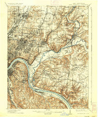
~ East Cincinnati OH topo map, 1:62500 scale, 15 X 15 Minute, Historical, 1914, updated 1936
East Cincinnati, Ohio, USGS topographic map dated 1914.
Includes geographic coordinates (latitude and longitude). This topographic map is suitable for hiking, camping, and exploring, or framing it as a wall map.
Printed on-demand using high resolution imagery, on heavy weight and acid free paper, or alternatively on a variety of synthetic materials.
Topos available on paper, Waterproof, Poly, or Tyvek. Usually shipping rolled, unless combined with other folded maps in one order.
- Product Number: USGS-5320860
- Free digital map download (high-resolution, GeoPDF): East Cincinnati, Ohio (file size: 10 MB)
- Map Size: please refer to the dimensions of the GeoPDF map above
- Weight (paper map): ca. 55 grams
- Map Type: POD USGS Topographic Map
- Map Series: HTMC
- Map Verison: Historical
- Cell ID: 53688
- Scan ID: 224938
- Imprint Year: 1936
- Survey Year: 1898
- Datum: NAD
- Map Projection: Polyconic
- Map published by United States Geological Survey
- Map Language: English
- Scanner Resolution: 600 dpi
- Map Cell Name: East Cincinnati
- Grid size: 15 X 15 Minute
- Date on map: 1914
- Map Scale: 1:62500
- Geographical region: Ohio, United States
Neighboring Maps:
All neighboring USGS topo maps are available for sale online at a variety of scales.
Spatial coverage:
Topo map East Cincinnati, Ohio, covers the geographical area associated the following places:
- Melbourne - Johns Hill - Fernell Heights - Salem Heights - Pendleton - Britney Acres - Sunny Acres - Walnut Hills - Ancor - Madisonville - Cincinnati - Columbia - Dillionvale - Mount Lookout - Hartwell - Stratford Manor - Am-Beth Acres - Glen Ridge Acres - Silver Grove - Mount Summit - Remington - Rendcomb Junction - Peebles Corner - Hyde Park - Fruit Hill - Hill Craft Acres - East Madisonville - Allandale (historical) - Dodsworth Lane (historical) - The Village of Indian Hill - Brookwood - Beechwood (historical) - Park Place - Avoca Park - Miami Grove - Raiders Run - Crestview - Fort Thomas - Home (historical) - Beverly Hills - Dallmans Corner - Montgomery - Brookhill - Fairwind Acres - Mount Carmel Heights - Beechview Estates - Romohr Acres - Al Bar Meadows - Miamiville - Withamsville - Mariemont - Indianview - Sundale - Sherwood Village - South Milford - Rossford - Holiday Acres - Turpin Hills - Linwood - Dayton - Cherry Grove - Sweetwine (historical) - Carthage - Dillonvale - Fairfax - Beech-Mar - Madeira - Bond Hill - Indian Hill - The Highlands - Glenwood (historical) - Blue Ash - Forest Hills Estates - Camp Springs - Foxhunter Lane - New Palestine - Branch Hill - Tobasco - Kenwood Hills - Montgomery Heights - Merwin - Compton Woods - Kennedy Heights - Newtown - Shademoore - Silverton - Beechwood - Idlewild - Arlington Heights - Kenwood - Barwyn Acres - Lawyerdale Estates - Milford - Rolling Knolls Estate - Asbury - Ellenora - Eightmile - Wyoming Meadows - Newport - Highland Heights
- Map Area ID: AREA39.2539-84.5-84.25
- Northwest corner Lat/Long code: USGSNW39.25-84.5
- Northeast corner Lat/Long code: USGSNE39.25-84.25
- Southwest corner Lat/Long code: USGSSW39-84.5
- Southeast corner Lat/Long code: USGSSE39-84.25
- Northern map edge Latitude: 39.25
- Southern map edge Latitude: 39
- Western map edge Longitude: -84.5
- Eastern map edge Longitude: -84.25


