
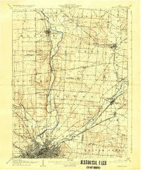
~ Dayton OH topo map, 1:62500 scale, 15 X 15 Minute, Historical, 1906, updated 1935
Dayton, Ohio, USGS topographic map dated 1906.
Includes geographic coordinates (latitude and longitude). This topographic map is suitable for hiking, camping, and exploring, or framing it as a wall map.
Printed on-demand using high resolution imagery, on heavy weight and acid free paper, or alternatively on a variety of synthetic materials.
Topos available on paper, Waterproof, Poly, or Tyvek. Usually shipping rolled, unless combined with other folded maps in one order.
- Product Number: USGS-5320828
- Free digital map download (high-resolution, GeoPDF): Dayton, Ohio (file size: 6 MB)
- Map Size: please refer to the dimensions of the GeoPDF map above
- Weight (paper map): ca. 55 grams
- Map Type: POD USGS Topographic Map
- Map Series: HTMC
- Map Verison: Historical
- Cell ID: 53234
- Scan ID: 224632
- Imprint Year: 1935
- Survey Year: 1904
- Datum: NAD
- Map Projection: Polyconic
- Map published by United States Geological Survey
- Map Language: English
- Scanner Resolution: 600 dpi
- Map Cell Name: Dayton
- Grid size: 15 X 15 Minute
- Date on map: 1906
- Map Scale: 1:62500
- Geographical region: Ohio, United States
Neighboring Maps:
All neighboring USGS topo maps are available for sale online at a variety of scales.
Spatial coverage:
Topo map Dayton, Ohio, covers the geographical area associated the following places:
- Castlewood Trailer Court - Red Oak Mobile Home Park - North Riverdale - Sunshine Mobile Home Park - Park Hills Crossing - Pleasant View - Keenan Avenue Mobile Home Park - Drive In Mobile Home Park - Brookwood Mobile Home Park - Medway - Avondale - Huber Mobile Home Park - Wright Patterson Mobile Home Park - Sherman's Trailer Park - Tipp City - Spanker - Sunny Acres Mobile Home Park - Park Layne - Sulphur Grove - Dixie View Trailer Park - Schauers Acres - Buckeye Mobile Home Park - Grayson - Fairview - Wrightview - Crystal Lakes Mobile Home Park - Evanston - Shiloh - Woodland Hills - East Dayton - Northridge - McMahan Mobile Home Park - Country Haven Mobile Home Park - Babbtown (historical) - Tadmor (historical) - Crystal Lakes - Honey Creek Village Mobile Home Park - Dayton - Huber Heights - Womacks Mobile Home Park - Park Layne Manor - Hooks Corner - Fairway Terrace Mobile Home Park - Woodland Hills Mobile Home Park - Valley Trailer Court - West Charleston - Thomas Trailer Park - Brandt - Harries - New Carlisle - Five Points - Simms (historical) - Upper Valley Trailer Court - Ginghamsburg - Timberlane Mobile Village - Park Terrace Mobile Home Park - Four Oaks Mobile Home Park - Avondale Trailer Court - Funderberg (historical) - Crown Village Mobile Park - Cowlesville - South Point Village Mobile Home Park - Riverside - Cornell Heights - Page Manor - Fairborn - Brown - Taylorsville - Phoneton - Miami Villa - Upper Dayton View - New Germany - Willowick - Woods Mobile Home Park - Shady Lawn Mobile Park - Riverdale - Fairborn Mobile Home Park - Murlin Heights - Daytonview - Laws Mobile Home Park - Beverly Gardens - Huffeysville (historical) - Vandalia
- Map Area ID: AREA4039.75-84.25-84
- Northwest corner Lat/Long code: USGSNW40-84.25
- Northeast corner Lat/Long code: USGSNE40-84
- Southwest corner Lat/Long code: USGSSW39.75-84.25
- Southeast corner Lat/Long code: USGSSE39.75-84
- Northern map edge Latitude: 40
- Southern map edge Latitude: 39.75
- Western map edge Longitude: -84.25
- Eastern map edge Longitude: -84


