
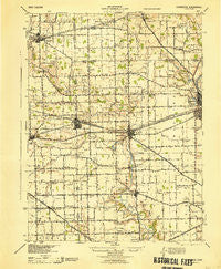
~ Covington OH topo map, 1:62500 scale, 15 X 15 Minute, Historical, 1944
Covington, Ohio, USGS topographic map dated 1944.
Includes geographic coordinates (latitude and longitude). This topographic map is suitable for hiking, camping, and exploring, or framing it as a wall map.
Printed on-demand using high resolution imagery, on heavy weight and acid free paper, or alternatively on a variety of synthetic materials.
Topos available on paper, Waterproof, Poly, or Tyvek. Usually shipping rolled, unless combined with other folded maps in one order.
- Product Number: USGS-5320812
- Free digital map download (high-resolution, GeoPDF): Covington, Ohio (file size: 6 MB)
- Map Size: please refer to the dimensions of the GeoPDF map above
- Weight (paper map): ca. 55 grams
- Map Type: POD USGS Topographic Map
- Map Series: HTMC
- Map Verison: Historical
- Cell ID: 53008
- Scan ID: 224573
- Woodland Tint: Yes
- Aerial Photo Year: 1940
- Survey Year: 1909
- Datum: NAD
- Map Projection: Polyconic
- Map published by United States Army Corps of Engineers
- Map published by United States Department of War
- Map Language: English
- Scanner Resolution: 600 dpi
- Map Cell Name: Covington
- Grid size: 15 X 15 Minute
- Date on map: 1944
- Map Scale: 1:62500
- Geographical region: Ohio, United States
Neighboring Maps:
All neighboring USGS topo maps are available for sale online at a variety of scales.
Spatial coverage:
Topo map Covington, Ohio, covers the geographical area associated the following places:
- Kensington - Rowdyville (historical) - Landin Park - Bradford - Overlook Trailer Park - Pamela Estates - Sugar Grove - Versailles - Pattytown - Covington - Stonebridge Meadows - Fairfield - Stonebridge - Recks Trailer Park - Carriage Crossing - Union Corners - Webster - Clayton - Painter Creek - Meyers (historical) - Pleasant Hill - Jimtown (historical) - Polo - Russia - Bloomer - Willowcreek - Mount Jefferson - Gettysburg - Ellemans (historical) - Red River - Edgewater - Kings Chapel - Circle Hill - Diltz Corners - Mulberry Grove - Fox Harbor - West Covington - North Jacksonville - Abe - Summitville (historical) - Miller Grove
- Map Area ID: AREA40.2540-84.5-84.25
- Northwest corner Lat/Long code: USGSNW40.25-84.5
- Northeast corner Lat/Long code: USGSNE40.25-84.25
- Southwest corner Lat/Long code: USGSSW40-84.5
- Southeast corner Lat/Long code: USGSSE40-84.25
- Northern map edge Latitude: 40.25
- Southern map edge Latitude: 40
- Western map edge Longitude: -84.5
- Eastern map edge Longitude: -84.25


