
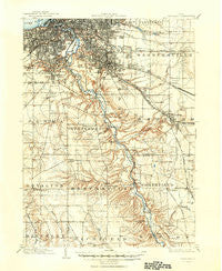
~ Cleveland OH topo map, 1:62500 scale, 15 X 15 Minute, Historical, 1903, updated 1950
Cleveland, Ohio, USGS topographic map dated 1903.
Includes geographic coordinates (latitude and longitude). This topographic map is suitable for hiking, camping, and exploring, or framing it as a wall map.
Printed on-demand using high resolution imagery, on heavy weight and acid free paper, or alternatively on a variety of synthetic materials.
Topos available on paper, Waterproof, Poly, or Tyvek. Usually shipping rolled, unless combined with other folded maps in one order.
- Product Number: USGS-5320782
- Free digital map download (high-resolution, GeoPDF): Cleveland, Ohio (file size: 7 MB)
- Map Size: please refer to the dimensions of the GeoPDF map above
- Weight (paper map): ca. 55 grams
- Map Type: POD USGS Topographic Map
- Map Series: HTMC
- Map Verison: Historical
- Cell ID: 52684
- Scan ID: 224479
- Imprint Year: 1950
- Survey Year: 1901
- Datum: NAD
- Map Projection: Polyconic
- Map published by United States Geological Survey
- Map Language: English
- Scanner Resolution: 600 dpi
- Map Cell Name: Cleveland
- Grid size: 15 X 15 Minute
- Date on map: 1903
- Map Scale: 1:62500
- Geographical region: Ohio, United States
Neighboring Maps:
All neighboring USGS topo maps are available for sale online at a variety of scales.
Spatial coverage:
Topo map Cleveland, Ohio, covers the geographical area associated the following places:
- University Heights - West Center - Walton Hills - Miller Mobile Homes - North Royalton - Valley View - Navy Park Housing Project (historical) - Tremont - Sorrento - Boston Heights - Chaffee (historical) - Ludlow - Dutch Alley - Ashbury Towers - The Angle - Oakwood - Alexander - Maple Heights - Highland Hills - Brooklyn Acres - Garden Valley - Northfield Center - Cuyahoga Heights - Hidden Cove Mobile Home Park - Macedonia - Valleyview Homes (historical) - Brandywine - Randall - Big Italy - Brecksville - Garfield Heights - South Brooklyn - Walling Corners - Wheelock (historical) - Enterprise (historical) - Boston - Bedford Heights - East Center - Willow - Parma - Cleveland - Ideal Mobile Home Park - Brooklyn Heights - Woodhill Homes - Sagamore Hills - Jaite - Emmons Corner - Ohio City - Mount Pleasant - Broadview Heights - Beachwood - Ledgewood Mobile Home Park - Slavic Village - Bedford - Broadview Gardens - Newburgh Heights - Warrensville - Pleasant Valley - Independence - Warrensville Heights - Glendale - Southpark - Lakeview Terrace - Northfield - Miles - Karlin - North Randall - Shaker Heights - Libby Aurora Mobile Home Park - Brooklyn - Ambler Heights - Seven Hills - Henry - Little York - Little Bohemia
- Map Area ID: AREA41.541.25-81.75-81.5
- Northwest corner Lat/Long code: USGSNW41.5-81.75
- Northeast corner Lat/Long code: USGSNE41.5-81.5
- Southwest corner Lat/Long code: USGSSW41.25-81.75
- Southeast corner Lat/Long code: USGSSE41.25-81.5
- Northern map edge Latitude: 41.5
- Southern map edge Latitude: 41.25
- Western map edge Longitude: -81.75
- Eastern map edge Longitude: -81.5


