
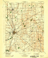
~ Circleville OH topo map, 1:62500 scale, 15 X 15 Minute, Historical, 1943
Circleville, Ohio, USGS topographic map dated 1943.
Includes geographic coordinates (latitude and longitude). This topographic map is suitable for hiking, camping, and exploring, or framing it as a wall map.
Printed on-demand using high resolution imagery, on heavy weight and acid free paper, or alternatively on a variety of synthetic materials.
Topos available on paper, Waterproof, Poly, or Tyvek. Usually shipping rolled, unless combined with other folded maps in one order.
- Product Number: USGS-5320768
- Free digital map download (high-resolution, GeoPDF): Circleville, Ohio (file size: 6 MB)
- Map Size: please refer to the dimensions of the GeoPDF map above
- Weight (paper map): ca. 55 grams
- Map Type: POD USGS Topographic Map
- Map Series: HTMC
- Map Verison: Historical
- Cell ID: 52608
- Scan ID: 224446
- Woodland Tint: Yes
- Datum: NAD
- Map Projection: Polyconic
- Map published by United States Army Corps of Engineers
- Map published by United States Department of War
- Map Language: English
- Scanner Resolution: 600 dpi
- Map Cell Name: Circleville
- Grid size: 15 X 15 Minute
- Date on map: 1943
- Map Scale: 1:62500
- Geographical region: Ohio, United States
Neighboring Maps:
All neighboring USGS topo maps are available for sale online at a variety of scales.
Spatial coverage:
Topo map Circleville, Ohio, covers the geographical area associated the following places:
- Nebraska (historical) - Elsea Mobile Village - Hayesville - Westfall - Saint Paul - Robs Trailer Park - Jefferson Estates - Squawtown (historical) - Voorheis (historical) - Ashton Village - Circle Hills - Suburban Village - Dels Trailer Park - Little Chicago - Ashville - Graystone Villas - Royalton - Huntsville - Cromley (historical) - Walnut - Elmwood - Gray (historical) - Meade - Wyandotte (historical) - Scioto Estates - Stoutsville - Leistville - Northwood Park - Brandon Court - Griffith (historical) - Logan Elm Village - Heathergreen - Knollwood Village - Ashton Crossing - Bells (historical) - Rhoads (historical) - Miller (historical) - Oak Park - Bridlewood - Stringtown - Hagerty (historical) - Tarlton - Morris Mobile Village - Circleville - J and J Trailer Park - Little Walnut - Sheldon (historical) - Dorney (historical) - Cedar Hill - Oakland - Spunkeytown (historical) - Fairview (historical) - Hooven (historical) - New Strasburg - Tedrows Mobile Home Park - Washington Meadows - Millport - Thacher - Brookside Park - Highlander Trailer Park - Campus Court - Eastmoor Subdivision - South Bloomfield - Millers (historical) - East Ringgold
- Map Area ID: AREA39.7539.5-83-82.75
- Northwest corner Lat/Long code: USGSNW39.75-83
- Northeast corner Lat/Long code: USGSNE39.75-82.75
- Southwest corner Lat/Long code: USGSSW39.5-83
- Southeast corner Lat/Long code: USGSSE39.5-82.75
- Northern map edge Latitude: 39.75
- Southern map edge Latitude: 39.5
- Western map edge Longitude: -83
- Eastern map edge Longitude: -82.75


