
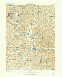
~ Athens OH topo map, 1:62500 scale, 15 X 15 Minute, Historical, 1903, updated 1958
Athens, Ohio, USGS topographic map dated 1903.
Includes geographic coordinates (latitude and longitude). This topographic map is suitable for hiking, camping, and exploring, or framing it as a wall map.
Printed on-demand using high resolution imagery, on heavy weight and acid free paper, or alternatively on a variety of synthetic materials.
Topos available on paper, Waterproof, Poly, or Tyvek. Usually shipping rolled, unless combined with other folded maps in one order.
- Product Number: USGS-5320652
- Free digital map download (high-resolution, GeoPDF): Athens, Ohio (file size: 11 MB)
- Map Size: please refer to the dimensions of the GeoPDF map above
- Weight (paper map): ca. 55 grams
- Map Type: POD USGS Topographic Map
- Map Series: HTMC
- Map Verison: Historical
- Cell ID: 50750
- Scan ID: 224834
- Imprint Year: 1958
- Survey Year: 1903
- Datum: NAD27
- Map Projection: Polyconic
- Map published by United States Geological Survey
- Map Language: English
- Scanner Resolution: 600 dpi
- Map Cell Name: Athens
- Grid size: 15 X 15 Minute
- Date on map: 1903
- Map Scale: 1:62500
- Geographical region: Ohio, United States
Neighboring Maps:
All neighboring USGS topo maps are available for sale online at a variety of scales.
Spatial coverage:
Topo map Athens, Ohio, covers the geographical area associated the following places:
- Beachwood Lake Estates - Modoc - Hamley Run - Luhrig - Orbiston - Grosvenor - Redtown - The Plains - New Marshfield - Morristown - Trimble - Glen Ebon - Armitage - Rolling Hills - Monday - Valley View - Hebardville - New Floodwood - Fullview Heights - Fairway Oaks - Bessemer - Rolling Hill Acres - Pine Grove Heights - Chauncey - Wonder Hills - Wonder Hills - New Mansfield - Carsey Town - Derthick - Elliottville - Truetown - Olbers - Sugar Creek - Greens Run - Marydale - Brookville - Beaumont - Candy Town - Liars Corner - Five Points - Jacksonville - Buchtel - Fisher - La Mar Heights - Hickory Hills - East Millfield - Nelsonville - Lewis (historical) - Highland Park Estates - Clearview - Longstreth - Athens - Goose Run (historical) - Cawthorn - Kimberly - Linscott (historical) - Lysander - Poston - University Heights - Longview Heights - Millfield - Doanville
- Map Area ID: AREA39.539.25-82.25-82
- Northwest corner Lat/Long code: USGSNW39.5-82.25
- Northeast corner Lat/Long code: USGSNE39.5-82
- Southwest corner Lat/Long code: USGSSW39.25-82.25
- Southeast corner Lat/Long code: USGSSE39.25-82
- Northern map edge Latitude: 39.5
- Southern map edge Latitude: 39.25
- Western map edge Longitude: -82.25
- Eastern map edge Longitude: -82


