
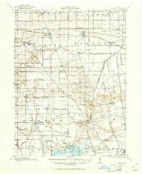
~ Alger OH topo map, 1:62500 scale, 15 X 15 Minute, Historical, 1913, updated 1961
Alger, Ohio, USGS topographic map dated 1913.
Includes geographic coordinates (latitude and longitude). This topographic map is suitable for hiking, camping, and exploring, or framing it as a wall map.
Printed on-demand using high resolution imagery, on heavy weight and acid free paper, or alternatively on a variety of synthetic materials.
Topos available on paper, Waterproof, Poly, or Tyvek. Usually shipping rolled, unless combined with other folded maps in one order.
- Product Number: USGS-5320602
- Free digital map download (high-resolution, GeoPDF): Alger, Ohio (file size: 6 MB)
- Map Size: please refer to the dimensions of the GeoPDF map above
- Weight (paper map): ca. 55 grams
- Map Type: POD USGS Topographic Map
- Map Series: HTMC
- Map Verison: Historical
- Cell ID: 50420
- Scan ID: 224720
- Imprint Year: 1961
- Survey Year: 1913
- Datum: NAD27
- Map Projection: Polyconic
- Map published by United States Geological Survey
- Map Language: English
- Scanner Resolution: 600 dpi
- Map Cell Name: Alger
- Grid size: 15 X 15 Minute
- Date on map: 1913
- Map Scale: 1:62500
- Geographical region: Ohio, United States
Neighboring Maps:
All neighboring USGS topo maps are available for sale online at a variety of scales.
Spatial coverage:
Topo map Alger, Ohio, covers the geographical area associated the following places:
- Holiday Shores Mobile Home Park - Belmont Court - Quickstep - West Newton - Jumbo - Roundhead - Waynesfield - Harrod - McGuffey - Chippewa Park - Avondale - Maysville - Alger - Island View - Tammis Mobile Village - New Hampshire - Holden - Jump - Tip and Jo's Trailer Park - Walton - Westminster - Huntersville - Blackhawk Mobile Home Park
- Map Area ID: AREA40.7540.5-84-83.75
- Northwest corner Lat/Long code: USGSNW40.75-84
- Northeast corner Lat/Long code: USGSNE40.75-83.75
- Southwest corner Lat/Long code: USGSSW40.5-84
- Southeast corner Lat/Long code: USGSSE40.5-83.75
- Northern map edge Latitude: 40.75
- Southern map edge Latitude: 40.5
- Western map edge Longitude: -84
- Eastern map edge Longitude: -83.75


