
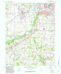
~ Trenton OH topo map, 1:24000 scale, 7.5 X 7.5 Minute, Historical, 1966, updated 1983
Trenton, Ohio, USGS topographic map dated 1966.
Includes geographic coordinates (latitude and longitude). This topographic map is suitable for hiking, camping, and exploring, or framing it as a wall map.
Printed on-demand using high resolution imagery, on heavy weight and acid free paper, or alternatively on a variety of synthetic materials.
Topos available on paper, Waterproof, Poly, or Tyvek. Usually shipping rolled, unless combined with other folded maps in one order.
- Product Number: USGS-5319882
- Free digital map download (high-resolution, GeoPDF): Trenton, Ohio (file size: 10 MB)
- Map Size: please refer to the dimensions of the GeoPDF map above
- Weight (paper map): ca. 55 grams
- Map Type: POD USGS Topographic Map
- Map Series: HTMC
- Map Verison: Historical
- Cell ID: 45618
- Scan ID: 226819
- Imprint Year: 1983
- Woodland Tint: Yes
- Photo Revision Year: 1981
- Aerial Photo Year: 1978
- Edit Year: 1981
- Field Check Year: 1955
- Datum: NAD27
- Map Projection: Polyconic
- Map published by United States Geological Survey
- Map published by: Military, Other
- Map Language: English
- Scanner Resolution: 600 dpi
- Map Cell Name: Trenton
- Grid size: 7.5 X 7.5 Minute
- Date on map: 1966
- Map Scale: 1:24000
- Geographical region: Ohio, United States
Neighboring Maps:
All neighboring USGS topo maps are available for sale online at a variety of scales.
Spatial coverage:
Topo map Trenton, Ohio, covers the geographical area associated the following places:
- Oneida - Woodsdale Park - Green Acres - Brookview - Maustown - Trenton - Snow Hill - South Excello - Woodsdale - Hughes - Greenlawn - Bon Veue - South Middletown - Rockdale - Country Club Highlands - Busenbark - Huntsville - Liberty Trails - Linn-Crest Acres - Country View Estates - Greystone - Princeton - Hunting Creek Estates - Le Sourdsville - Brofield Estates - North Excello - Arbor Crest - Dutchland Woods - Excello - Kyles
- Map Area ID: AREA39.539.375-84.5-84.375
- Northwest corner Lat/Long code: USGSNW39.5-84.5
- Northeast corner Lat/Long code: USGSNE39.5-84.375
- Southwest corner Lat/Long code: USGSSW39.375-84.5
- Southeast corner Lat/Long code: USGSSE39.375-84.375
- Northern map edge Latitude: 39.5
- Southern map edge Latitude: 39.375
- Western map edge Longitude: -84.5
- Eastern map edge Longitude: -84.375


