
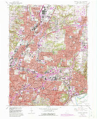
~ Cincinnati East OH topo map, 1:24000 scale, 7.5 X 7.5 Minute, Historical, 1961, updated 1988
Cincinnati East, Ohio, USGS topographic map dated 1961.
Includes geographic coordinates (latitude and longitude). This topographic map is suitable for hiking, camping, and exploring, or framing it as a wall map.
Printed on-demand using high resolution imagery, on heavy weight and acid free paper, or alternatively on a variety of synthetic materials.
Topos available on paper, Waterproof, Poly, or Tyvek. Usually shipping rolled, unless combined with other folded maps in one order.
- Product Number: USGS-5315796
- Free digital map download (high-resolution, GeoPDF): Cincinnati East, Ohio (file size: 19 MB)
- Map Size: please refer to the dimensions of the GeoPDF map above
- Weight (paper map): ca. 55 grams
- Map Type: POD USGS Topographic Map
- Map Series: HTMC
- Map Verison: Historical
- Cell ID: 8773
- Scan ID: 226397
- Imprint Year: 1988
- Woodland Tint: Yes
- Visual Version Number: 1
- Photo Revision Year: 1981
- Aerial Photo Year: 1979
- Edit Year: 1981
- Field Check Year: 1953
- Datum: NAD27
- Map Projection: Polyconic
- Map published by United States Geological Survey
- Map Language: English
- Scanner Resolution: 600 dpi
- Map Cell Name: Cincinnati East
- Grid size: 7.5 X 7.5 Minute
- Date on map: 1961
- Map Scale: 1:24000
- Geographical region: Ohio, United States
Neighboring Maps:
All neighboring USGS topo maps are available for sale online at a variety of scales.
Spatial coverage:
Topo map Cincinnati East, Ohio, covers the geographical area associated the following places:
- Stratford Manor - Linwood - Wyoming - Rendcomb Junction - Red Bank - O'Bryonsville - Park Place - Norwood - Peebles Corner - Arbocrest Acres - Oakley Square - Idlewild - Evanston - Edgemont - Brookwood - Clare - Amity - Woodburn - Indian Hill - Kenwood Hills - Lincoln Heights - Kennedy Heights - Dillionvale - Norwood Heights - Silverton - Amberley - Whitetree - Ivorydale - North Sagamore Heights - Madisonville - Fairfax - Oakley - Rolling Knolls Estate - Rossmoyne - Holiday Acres - Golf Manor - Blue Ash - Walnut Hills - Cincinnati - Faxon Hills - Hartwell - Hill Top Acres - Kenwood Knolls - Mount Lookout - Dillonvale - Brookhill - Avondale - Idlewood - East Madisonville - Dallmans Corner - Harewood Acres - Carthage - Elmwood Place - Deer Park - Bond Hill - Pleasant Ridge - Reading - Valleydale - Lockland - Roselawn - Hyde Park - Saint Bernard - Country Club Acres - Arlington Heights - Compton Woods - Wyoming Meadows - Beechwood
- Map Area ID: AREA39.2539.125-84.5-84.375
- Northwest corner Lat/Long code: USGSNW39.25-84.5
- Northeast corner Lat/Long code: USGSNE39.25-84.375
- Southwest corner Lat/Long code: USGSSW39.125-84.5
- Southeast corner Lat/Long code: USGSSE39.125-84.375
- Northern map edge Latitude: 39.25
- Southern map edge Latitude: 39.125
- Western map edge Longitude: -84.5
- Eastern map edge Longitude: -84.375


