
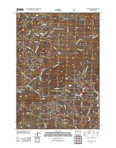
~ Steins Pillar OR topo map, 1:24000 scale, 7.5 X 7.5 Minute, Historical, 2011
Steins Pillar, Oregon, USGS topographic map dated 2011.
Includes geographic coordinates (latitude and longitude). This topographic map is suitable for hiking, camping, and exploring, or framing it as a wall map.
Printed on-demand using high resolution imagery, on heavy weight and acid free paper, or alternatively on a variety of synthetic materials.
Topos available on paper, Waterproof, Poly, or Tyvek. Usually shipping rolled, unless combined with other folded maps in one order.
- Product Number: USGS-5295166
- Free digital map download (high-resolution, GeoPDF): Steins Pillar, Oregon (file size: 29 MB)
- Map Size: please refer to the dimensions of the GeoPDF map above
- Weight (paper map): ca. 55 grams
- Map Type: POD USGS Topographic Map
- Map Series: US Topo
- Map Verison: Historical
- Cell ID: 43081
- Datum: North American Datum of 1983
- Map Projection: Transverse Mercator
- Map Cell Name: Steins Pillar
- Grid size: 7.5 X 7.5 Minute
- Date on map: 2011
- Map Scale: 1:24000
- Geographical region: Oregon, United States
Neighboring Maps:
All neighboring USGS topo maps are available for sale online at a variety of scales.
Spatial coverage:
Topo map Steins Pillar, Oregon, covers the geographical area associated the following places:
- Cayuse Forest Camp - Mill Creek Wilderness - Doe Creek - Lakin Place - White Rock Recreation Site - Wildcat Mountain - Prineville Division - Harvey Creek - Belknap Creek - Jim Elliott Creek - Barney Post Office (historical) - Fintcher Creek - Steins Pillar - Swamp Spring - Wildcat Recreation Site - Brogan Creek - Rocky Butte - Dorn Spring - West Fork Mill Creek - Lemon Creek - East Fork Mill Creek - Rock Spring - Sears Creek - Hash Rock - White Rock Spring - Jesse Spring - White Fir Spring - Hash Rock Creek - Forked Horn Butte - Hawthorne Spring - Benefield Creek - Jackson Spring - Desolation Canyon - Squirrel Ridge - Barney - King Spring - Riley Creek - Twin Pillars
- Map Area ID: AREA44.544.375-120.625-120.5
- Northwest corner Lat/Long code: USGSNW44.5-120.625
- Northeast corner Lat/Long code: USGSNE44.5-120.5
- Southwest corner Lat/Long code: USGSSW44.375-120.625
- Southeast corner Lat/Long code: USGSSE44.375-120.5
- Northern map edge Latitude: 44.5
- Southern map edge Latitude: 44.375
- Western map edge Longitude: -120.625
- Eastern map edge Longitude: -120.5


