
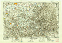
~ Evansville IN topo map, 1:250000 scale, 1 X 2 Degree, Historical, 1954
Evansville, Indiana, USGS topographic map dated 1954.
Includes geographic coordinates (latitude and longitude). This topographic map is suitable for hiking, camping, and exploring, or framing it as a wall map.
Printed on-demand using high resolution imagery, on heavy weight and acid free paper, or alternatively on a variety of synthetic materials.
Topos available on paper, Waterproof, Poly, or Tyvek. Usually shipping rolled, unless combined with other folded maps in one order.
- Product Number: USGS-5289230
- Free digital map download (high-resolution, GeoPDF): Evansville, Indiana (file size: 16 MB)
- Map Size: please refer to the dimensions of the GeoPDF map above
- Weight (paper map): ca. 55 grams
- Map Type: POD USGS Topographic Map
- Map Series: HTMC
- Map Verison: Historical
- Cell ID: 68772
- Scan ID: 156917
- Aerial Photo Year: 1947
- Datum: NAD27
- Map Projection: Transverse Mercator
- Shaded Relief map: Yes
- Map published by United States Geological Survey
- Map Language: English
- Scanner Resolution: 600 dpi
- Map Cell Name: Evansville
- Grid size: 1 X 2 Degree
- Date on map: 1954
- Map Scale: 1:250000
- Geographical region: Indiana, United States
Neighboring Maps:
All neighboring USGS topo maps are available for sale online at a variety of scales.
Spatial coverage:
Topo map Evansville, Indiana, covers the geographical area associated the following places:
- Tilford - Rose Hill - Rosetta - Conoloway - Higdon - Turnertown - Grancer - Rock Springs (historical) - Meredith - Kirk - Ponderosa - Rockport - Deanefield - Waverly - Hitesville - Highland Springs - Jason - Rustic Hills - Horton - Free Union - Little Mountain (historical) - Mook - Brownsville - Anton - Penns Chapel (historical) - Shelton - Franklin Cross Roads - Luzerne - Stephensport - Crowtown - Hebbardsville - Rochester - White Sulphur - Coffman - Dayville - Askin - Topeka Crossroads (historical) - Sandefur Crossing - Stockholm - Hartford - Jagoe - Nortonville - Pueblo - Rome - Heusler - Graham Hill - Herbert - Nuckols - Woodcrest - Princeton - Carlinburg - Rays Branch (historical) - Eastview - Dozier Heights - Lilac - Smallhous - Ortiz - Pierce Mill - Vertrees - Black Gold - Elko - Fordsville - Glenmore - Fryer - Saint Lawrence (historical) - Shrote - Rockland - Richelieu - Rosewood - Horntown - Lilmay (historical) - Maceo - Henry - Adams (historical) - Calhoun - West Wheatcroft - Rangers Landing - Yankeetown - Graham - Cedar Bluff - Twin Lakes - Arnold (historical) - Boxville - Brentwood - Grandview - Boston - Stanhope - Manitou - Rosebud (historical) - Diamond Springs - Flournoy - Thomas Store (historical) - West Clifty - Stringtown - Dug Hill (historical) - Johnson Island (historical) - Vineyard - Needmore - Knightsburg - Reed
- Map Area ID: AREA3837-88-86
- Northwest corner Lat/Long code: USGSNW38-88
- Northeast corner Lat/Long code: USGSNE38-86
- Southwest corner Lat/Long code: USGSSW37-88
- Southeast corner Lat/Long code: USGSSE37-86
- Northern map edge Latitude: 38
- Southern map edge Latitude: 37
- Western map edge Longitude: -88
- Eastern map edge Longitude: -86


