
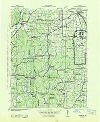
~ Franklin IN topo map, 1:125000 scale, 30 X 30 Minute, Historical, 1942
Franklin, Indiana, USGS topographic map dated 1942.
Includes geographic coordinates (latitude and longitude). This topographic map is suitable for hiking, camping, and exploring, or framing it as a wall map.
Printed on-demand using high resolution imagery, on heavy weight and acid free paper, or alternatively on a variety of synthetic materials.
Topos available on paper, Waterproof, Poly, or Tyvek. Usually shipping rolled, unless combined with other folded maps in one order.
- Product Number: USGS-5289216
- Free digital map download (high-resolution, GeoPDF): Franklin, Indiana (file size: 8 MB)
- Map Size: please refer to the dimensions of the GeoPDF map above
- Weight (paper map): ca. 55 grams
- Map Type: POD USGS Topographic Map
- Map Series: HTMC
- Map Verison: Historical
- Cell ID: 65517
- Scan ID: 156510
- Woodland Tint: Yes
- Aerial Photo Year: 1941
- Datum: NAD27
- Map Projection: Polyconic
- Map published by United States Army Corps of Engineers
- Map published by United States Department of War
- Map Language: English
- Scanner Resolution: 600 dpi
- Map Cell Name: Franklin
- Grid size: 30 X 30 Minute
- Date on map: 1942
- Map Scale: 1:125000
- Geographical region: Indiana, United States
Neighboring Maps:
All neighboring USGS topo maps are available for sale online at a variety of scales.
Spatial coverage:
Topo map Franklin, Indiana, covers the geographical area associated the following places:
- Peoga - Stony Lonesome - Nashville - Chetwynd - Maxwell - Camp Roberts - McDaniel - Sweetwater Lake - Nineveh - Shelburne - Belmont - Fewell Rhoades - Hindustan - Ogilville - Lake on the Green - Trevlac - Waycross - Turkey Track - Cordry Sweetwater Lakes - Elk - Morgantown - Mahalasville - Maple Grove Village Mobile Home Park - Trafalgar - Painted Hills - Bud - Laveianan Court - Fairfax - Mount Pleasant - Woodville Hills - Samaria - Hickman's Trailer Park - Cornelius - Unionville - Story - Bear Wallow - Helmsburg - Needmore - Kansas - Fruitdale - Stines Mill Corner - Hoosier Acres - Lanam - Gatesville - Princes Lakes - Amity - Stone Head - Becks Grove - Wolff - Frakers Mobile Home Court - Elkinsville - Annandale Estates - Spearsville - Champlin Meadows - Bald Knobs - Christiansburg - Anita - Dolan - Willowbrook Estates - Hyndsdale - Prather - Knight Ridge - Fleener - Cope - Spraytown - Spurgeons Corner - Clarksdale - Bethany - Gnaw Bone - Martinsville - Youno (historical) - Point Idalawn - Wooded Hills Mobile Home Park - Waymansville - Woodcrest - Hopewell - Mount Liberty - Hick's Mobile Home Park - Taggart - Pikes Peak - Stratford (historical) - West Overlook - Providence - New Unionville - Franklin - Taggart Crossing - North Ogilville - Mount Healthy - Adams - Handy - Buffalo (historical) - Houston - Grandview Lake - Maumee - Spring Valley Mobile Home Park - Beanblossom - Town Hill - Eastern Heights
- Map Area ID: AREA39.539-86.5-86
- Northwest corner Lat/Long code: USGSNW39.5-86.5
- Northeast corner Lat/Long code: USGSNE39.5-86
- Southwest corner Lat/Long code: USGSSW39-86.5
- Southeast corner Lat/Long code: USGSSE39-86
- Northern map edge Latitude: 39.5
- Southern map edge Latitude: 39
- Western map edge Longitude: -86.5
- Eastern map edge Longitude: -86


