
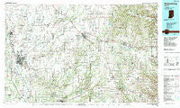
~ Greensburg IN topo map, 1:100000 scale, 30 X 60 Minute, Historical, 1986, updated 1989
Greensburg, Indiana, USGS topographic map dated 1986.
Includes geographic coordinates (latitude and longitude). This topographic map is suitable for hiking, camping, and exploring, or framing it as a wall map.
Printed on-demand using high resolution imagery, on heavy weight and acid free paper, or alternatively on a variety of synthetic materials.
Topos available on paper, Waterproof, Poly, or Tyvek. Usually shipping rolled, unless combined with other folded maps in one order.
- Product Number: USGS-5289152
- Free digital map download (high-resolution, GeoPDF): Greensburg, Indiana (file size: 23 MB)
- Map Size: please refer to the dimensions of the GeoPDF map above
- Weight (paper map): ca. 55 grams
- Map Type: POD USGS Topographic Map
- Map Series: HTMC
- Map Verison: Historical
- Cell ID: 67608
- Scan ID: 159919
- Imprint Year: 1989
- Woodland Tint: Yes
- Aerial Photo Year: 1984
- Edit Year: 1986
- Datum: NAD27
- Map Projection: Universal Transverse Mercator
- Map published by United States Geological Survey
- Map Language: English
- Scanner Resolution: 600 dpi
- Map Cell Name: Greensburg
- Grid size: 30 X 60 Minute
- Date on map: 1986
- Map Scale: 1:100000
- Geographical region: Indiana, United States
Neighboring Maps:
All neighboring USGS topo maps are available for sale online at a variety of scales.
Spatial coverage:
Topo map Greensburg, Indiana, covers the geographical area associated the following places:
- New Pennington - Saint Maurice - Waynesville - Dillsboro Station - Brookville - Jewell Village - Millville - Nortonburg - Riverview Acres - Lookout - Pleasure Valley - Harris City - Petersville - Cuba - Corn Brook - Lake View - Cross Roads - Osgood - Allen Crossing - Dillsboro - Wilson Corner - Garden City - Scipio - Rossburg - Laugheryville - Westport - Morven - Flat Rock Park - Dabney - Old Milan - Sleepy Hollow - Greensburg - Penntown - Pinhook - Spades - Smyrna - Hamburg - Oak Forest - Chesterville - Mechanicsburg - Reddington - Geneva - Saint Marys - Metamora - Weisburg - Adams - Middletown - Bobtown - Camp Flat Rock - Clarksburg - Prattsburg - Buena Vista - Slabtown - Waynesburg - Lowell - Moores Hill - Germantown - Sunman - Country Squire Lakes - Morris - Manchester - Jonesville - Burney - Negangards Corner - Sandusky - Hubbells Corner - Forest Park - New Point - Northcliff - Butlerville - Rosstown - Fenns - Sparta - Milroy - Hope - Stavetown - Sardinia - Enochsburg - Elrod - Saint Peter - Zenas - Everroad Park - Holton - Craig - Smiths Crossing - Taylorsville - Letts - Bethel Village - North Park - Parkside - Stumpke Corner - Peppertown - Edinburgh - North Columbus - Delaware - Gaynorsville - Midway - Laughery Switch - Lewis Creek - Lawrenceville
- Map Area ID: AREA39.539-86-85
- Northwest corner Lat/Long code: USGSNW39.5-86
- Northeast corner Lat/Long code: USGSNE39.5-85
- Southwest corner Lat/Long code: USGSSW39-86
- Southeast corner Lat/Long code: USGSSE39-85
- Northern map edge Latitude: 39.5
- Southern map edge Latitude: 39
- Western map edge Longitude: -86
- Eastern map edge Longitude: -85


