
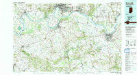
~ Evansville IN topo map, 1:100000 scale, 30 X 60 Minute, Historical, 1991, updated 1991
Evansville, Indiana, USGS topographic map dated 1991.
Includes geographic coordinates (latitude and longitude). This topographic map is suitable for hiking, camping, and exploring, or framing it as a wall map.
Printed on-demand using high resolution imagery, on heavy weight and acid free paper, or alternatively on a variety of synthetic materials.
Topos available on paper, Waterproof, Poly, or Tyvek. Usually shipping rolled, unless combined with other folded maps in one order.
- Product Number: USGS-5289144
- Free digital map download (high-resolution, GeoPDF): Evansville, Indiana (file size: 24 MB)
- Map Size: please refer to the dimensions of the GeoPDF map above
- Weight (paper map): ca. 55 grams
- Map Type: POD USGS Topographic Map
- Map Series: HTMC
- Map Verison: Historical
- Cell ID: 67494
- Scan ID: 156830
- Imprint Year: 1991
- Woodland Tint: Yes
- Aerial Photo Year: 1988
- Edit Year: 1991
- Datum: NAD27
- Map Projection: Universal Transverse Mercator
- Map published by United States Geological Survey
- Map Language: English
- Scanner Resolution: 600 dpi
- Map Cell Name: Evansville
- Grid size: 30 X 60 Minute
- Date on map: 1991
- Map Scale: 1:100000
- Geographical region: Indiana, United States
Neighboring Maps:
All neighboring USGS topo maps are available for sale online at a variety of scales.
Spatial coverage:
Topo map Evansville, Indiana, covers the geographical area associated the following places:
- Rock Springs - Euterpe - Covent Gardens (historical) - Gatesville - Stanley - Vanada - Hitesville - Hickman (historical) - Jewel City - Poole - Heflin - Utica - Farmersville - Hovey - Beals - Flournoy - Sturgis - Breton - Paradise - Elmwood - Morganfield - Chelsea (historical) - Arnold - Jonesburg - Beech Grove - Breckinridge Center - Carlinburg - Mud Center - Lincoln Pioneer Village - Pyeattville - Uniontown - Dead Mans Crossing - Mount Vernon - Broad Acres - Elba - Smythe - McClure (historical) - Pueblo - Red Bush - Tilden - Rahm - Graham Hill - Reo - Comer - Marrs Center - Moseleyville - Enterprise - Wanamaker - Livia - Little Zion - Robinsville - Evansville - Wilson - Sutherland - Ritchie - Hunters Ridge - Finley Addition - Thruston - West Franklin - Normandy Heights - Dermont - Rumsey - Mount Vernon - Rock Hill - Rankin - Snyder - Boxville - Laketown (historical) - Birk City - Williams - Heusler - Patronville - Johnson Island - Bluff City - Mayo Hills (historical) - Brook Hill Estates - Wrightsburg - Glenville - Dayville - Quinn Landing - Hatfield - Brownwood Manor - West Louisville - Robards - Hearin - Pratt - King Mills - Bufkin - Cleopatra - Pettit - Philip Station - Browns Valley - Weaverton - Yankeetown - Eureka - Spencer County Farm - Dixon - Lake Mill - Maxwell - Oak Ridge
- Map Area ID: AREA3837.5-88-87
- Northwest corner Lat/Long code: USGSNW38-88
- Northeast corner Lat/Long code: USGSNE38-87
- Southwest corner Lat/Long code: USGSSW37.5-88
- Southeast corner Lat/Long code: USGSSE37.5-87
- Northern map edge Latitude: 38
- Southern map edge Latitude: 37.5
- Western map edge Longitude: -88
- Eastern map edge Longitude: -87


