
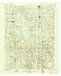
~ Haubstadt IN topo map, 1:62500 scale, 15 X 15 Minute, Historical, 1903, updated 1935
Haubstadt, Indiana, USGS topographic map dated 1903.
Includes geographic coordinates (latitude and longitude). This topographic map is suitable for hiking, camping, and exploring, or framing it as a wall map.
Printed on-demand using high resolution imagery, on heavy weight and acid free paper, or alternatively on a variety of synthetic materials.
Topos available on paper, Waterproof, Poly, or Tyvek. Usually shipping rolled, unless combined with other folded maps in one order.
- Product Number: USGS-5289008
- Free digital map download (high-resolution, GeoPDF): Haubstadt, Indiana (file size: 7 MB)
- Map Size: please refer to the dimensions of the GeoPDF map above
- Weight (paper map): ca. 55 grams
- Map Type: POD USGS Topographic Map
- Map Series: HTMC
- Map Verison: Historical
- Cell ID: 55158
- Scan ID: 159744
- Imprint Year: 1935
- Survey Year: 1901
- Datum: Unstated
- Map Projection: Polyconic
- Map published by United States Geological Survey
- Map Language: English
- Scanner Resolution: 600 dpi
- Map Cell Name: Haubstadt
- Grid size: 15 X 15 Minute
- Date on map: 1903
- Map Scale: 1:62500
- Geographical region: Indiana, United States
Neighboring Maps:
All neighboring USGS topo maps are available for sale online at a variety of scales.
Spatial coverage:
Topo map Haubstadt, Indiana, covers the geographical area associated the following places:
- Melody Hill - Darmstadt - Crossroads (historical) - Stacer - Lakewood Hills - Saint James - Martin - Country Club Meadows - Saint Joseph - Harwood - Erskine Station - Kasson - Armstrong - Nisbet - Highland - Hillsdale - Earle - McCutchanville - Saint Wendel - Haubstadt - Warrenton - Mounts - Mechanicsville - Stringtown - Knob Hill - Kratzville - Parkers Settlement - Cynthiana - Inglefield
- Map Area ID: AREA38.2538-87.75-87.5
- Northwest corner Lat/Long code: USGSNW38.25-87.75
- Northeast corner Lat/Long code: USGSNE38.25-87.5
- Southwest corner Lat/Long code: USGSSW38-87.75
- Southeast corner Lat/Long code: USGSSE38-87.5
- Northern map edge Latitude: 38.25
- Southern map edge Latitude: 38
- Western map edge Longitude: -87.75
- Eastern map edge Longitude: -87.5


