
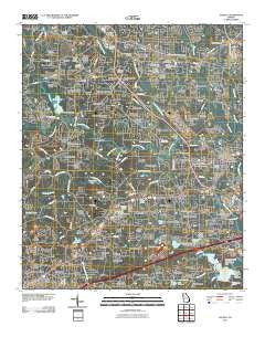
~ Austell GA topo map, 1:24000 scale, 7.5 X 7.5 Minute, Historical, 2011
Austell, Georgia, USGS topographic map dated 2011.
Includes geographic coordinates (latitude and longitude). This topographic map is suitable for hiking, camping, and exploring, or framing it as a wall map.
Printed on-demand using high resolution imagery, on heavy weight and acid free paper, or alternatively on a variety of synthetic materials.
Topos available on paper, Waterproof, Poly, or Tyvek. Usually shipping rolled, unless combined with other folded maps in one order.
- Product Number: USGS-5246762
- Free digital map download (high-resolution, GeoPDF): Austell, Georgia (file size: 18 MB)
- Map Size: please refer to the dimensions of the GeoPDF map above
- Weight (paper map): ca. 55 grams
- Map Type: POD USGS Topographic Map
- Map Series: US Topo
- Map Verison: Historical
- Cell ID: 1894
- Datum: North American Datum of 1983
- Map Projection: Transverse Mercator
- Map Cell Name: Austell
- Grid size: 7.5 X 7.5 Minute
- Date on map: 2011
- Map Scale: 1:24000
- Geographical region: Georgia, United States
Neighboring Maps:
All neighboring USGS topo maps are available for sale online at a variety of scales.
Spatial coverage:
Topo map Austell, Georgia, covers the geographical area associated the following places:
- Foxboro - Wexford Estates - McKenny Acres - Tammy Heights - Pine Oaks - Brannons Branch - Austell - Southern Pines Estates - Lake Estates - Park Place - Sunset Hill - Leisure Acres - Beulah - Brook Forest Mobile Home Park - Anna Bella Estates - Pinebrook Mobile Home Park - Harpers Lake - Stoneybrook - Ellis - Springbrook - Midway Estates - County Line Heights - Rocky Hills - Stonewood - Pinecrest Estates - Leeward Park - Colonial Estates - Brookwood Acres - North Kingsley Estates - Oak Hill - Bannister Acres - Beech Gum Mobile Home Park - Fairfax - Ansley Park - West Springs - Hickory Forest - Lakeland Hills - Midway Mobile Home Park - Mann Manor - Merlin Meadows - Forest Acres - Pineview - Young Park - Heritage Square - Lithia Springs - Westridge - Walker Place - Hillsdale Heights - Malone Park - Parkway Estates - Powder Ridge - Forkwood - Powder Springs Chase - James Heights - Plantation Estates Mobile Home Park - Douglasville - Sullivan Heights - Brookstone - Pine Valley Estates - Pleasant Hills - High Point - Park Forest - Killarney Hills - Powder Springs - Beechwood Hills - Paris Manor - Greenfield Chase - Kellogg - Wesley Station - Springtime Mobile Home Park - Boulder Park Estates - County Line Place - Durelle - McKown - Whitaker Hills - Skyview - Lawrence Estates - Deerfield - Trail Creek - Lithia Mobile Home Estates - Cumberland Forest - Falcon Acres - The Willows - Forest Glen - English Heights - Clarkdale - Wasilla Estates - Lakeside Mobile Home Park - Connally - Deerbrook Estates - Burnt Hickory Estates - Indian Rose - Skyview Heights - Hickory Glen - Midway - Forest Heights - Burnt Hickory Farms - Steeplechase - Georgian Heights - Sherwood Park
- Map Area ID: AREA33.87533.75-84.75-84.625
- Northwest corner Lat/Long code: USGSNW33.875-84.75
- Northeast corner Lat/Long code: USGSNE33.875-84.625
- Southwest corner Lat/Long code: USGSSW33.75-84.75
- Southeast corner Lat/Long code: USGSSE33.75-84.625
- Northern map edge Latitude: 33.875
- Southern map edge Latitude: 33.75
- Western map edge Longitude: -84.75
- Eastern map edge Longitude: -84.625


