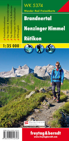
WK 5374 Brandnertal - Nenzinger Himmel - Rätikon, hiking map 1:35,000
Freytag & Berndt hiking maps are ideal companions in hiking, mountaineering and on ski tours thanks to the detailed digital cartography and the exact standards. They are regularly revised and contain updated information on hiking trails, bike and mountain bike routes, huts, natural monuments, cultural sights and leisure facilities. The enclosed information booklet contains a selection of the best hiking trails, bike paths and mountain bike routes as well as a brief description of the individual communities with their leisure activities. (Language: German) leisure information, hiking and long-distance hiking trails, mountain bike and bike tours, local register with postcodes, GPS-compatible, via ferrata, referee, cross-country route; Region: Brandnertal, Nenzingen Heaven, Rätikon, Montafon, Lechtaler Alpen; Special hiking themes: Central Alpine path, Jakobsweg, Via Alpina, Zimbajoch round tour, Golmi’s research path, around Lünersee, two-day tour on the Schesaplana; Special cycling and
- Product Number: FB_WK_5374_19
- Reference Product Number: - None -
- ISBN: 9783707912753
- Date of Publication: 10/3/2016
- Folded Size: 8.06 inches high by 3.93 inches wide
- Unfolded (flat) Size: 8.06 inches high by 3.93 inches wide
- Map format: Folded
- Map type: Trade Maps - Hiking
- Geographical region: Austria