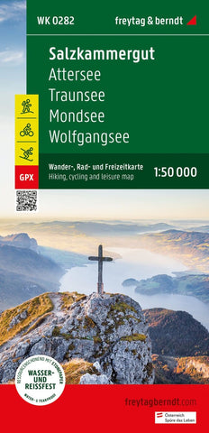
Salzkammergut, hiking, bike and leisure map 1:50,000 WK 0282
The Hiking Map Salzkammergut is regularly revised and contains updated information about hiking trails, bike and mountain bike routes, huts, natural monuments, cultural sights and leisure facilities. The enclosed information booklet contains a selection of the best hiking trails, bike paths and mountain bike routes as well as a brief description of the individual communities with their leisure activities. (Language: German) leisure information, hiking and long-distance hiking trails, mountain bike and bike tours, local register with postcodes, GPS-suitable, via ferrata, referee, cross-country route, Nordic walking route; Region: Salzkammergut, Mondseeland, Attergau; Long-distance hiking trails and special hiking themes: Voralpenweg, E4, Salzburger Mariazellerweg, Wolfgangweg, Salzkammergut Berge-Seen-Trail, pilgrimage path, via Nova, Arnoweg, Jakobsweg, St. Rupert Pilgerweg, WEG of the book, Schafberg-Talwalung, Mondsee-Stauba-hiking , Langbathsee round hike; Special cycling and moun
- Product Number: FB_WK_50_282_23
- Reference Product Number: - None -
- ISBN: 9783707919431
- Date of Publication: 6/15/2023
- Folded Size: 8.06 inches high by 3.93 inches wide
- Unfolded (flat) Size: 8.06 inches high by 3.93 inches wide
- Map format: Folded
- Map type: Trade Maps - Hiking
- Geographical region: Austria