
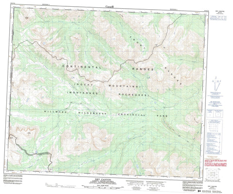
083E13 Dry Canyon Canada topo map, 1:50,000 scale
083E13 Dry Canyon NRCAN topographic map.
Includes UTM and GPS geographic coordinates (latitude and longitude). This 50k scale map is suitable for hiking, camping, and exploring, or you could frame it as a wall map.
Printed on-demand using high resolution, on heavy weight and acid free paper, or as an upgrade on a variety of synthetic materials.
Topos available on paper, Waterproof, Poly, or Tyvek. Usually shipping rolled, unless combined with other folded maps in one order.
- Product Number: NRCAN-083E13
- Parent Topo: TOPO-083E
- Map ID also known as: 083E13, 83E13
- Unfolded Size: Approximately 26" high by 36" wide
- Weight (paper map): ca. 55 grams
- Map Type: POD NRCAN Topographic Map
- Map Scale: 1:50,000
- Geographical region: Alberta, Canada
Neighboring Maps:
All neighboring Canadian topo maps are available for sale online at 1:50,000 scale.
Purchase the smaller scale map covering this area: Topo-083E
Spatial coverage:
Topo map sheet 083E13 Dry Canyon covers the following places:
- Casket Lake - Casket Mountain - Intersection Mountain - Intersection Mountain - La Crèche Mountain - Montagnes Rocheuses - Montagnes Rocheuses - Mount Côté - Mount Côté - Park Ranges - Rim Ridge - Rocky Mountains - Rocky Mountains - Turret Ridge - Cariboo Regional District - Municipal District of Greenview No. 16 - Regional District of Fraser-Fort George - Improvement District No. 25 - Willmore Wilderness Provincial Park - Bear Creek - Casket Creek - Famm Creek - Fetherstonhaugh Creek - Forgetmenot Creek - Glacier Creek - Haight Creek - Horn Creek - Llama Creek - Muddywater River - Narrow Creek - Putzy Creek - Sheep Creek - South Kakwa River - Swift Creek - Trench Creek - Dry Canyon Trail - Sheep Creek Trail - Casket Pass - Casket Pass - Copton Pass - Dry Canyon - Forgetmenot Pass - Forgetmenot Pass - Paradise Basin


