
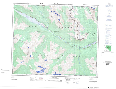
083D15 Lucerne Canada topo map, 1:50,000 scale
083D15 Lucerne NRCAN topographic map.
Includes UTM and GPS geographic coordinates (latitude and longitude). This 50k scale map is suitable for hiking, camping, and exploring, or you could frame it as a wall map.
Printed on-demand using high resolution, on heavy weight and acid free paper, or as an upgrade on a variety of synthetic materials.
Topos available on paper, Waterproof, Poly, or Tyvek. Usually shipping rolled, unless combined with other folded maps in one order.
- Product Number: NRCAN-083D15
- Parent Topo: TOPO-083D
- Map ID also known as: 083D15, 83D15
- Unfolded Size: Approximately 26" high by 36" wide
- Weight (paper map): ca. 55 grams
- Map Type: POD NRCAN Topographic Map
- Map Scale: 1:50,000
- Geographical region: Alberta, Canada
Neighboring Maps:
All neighboring Canadian topo maps are available for sale online at 1:50,000 scale.
Purchase the smaller scale map covering this area: Topo-083D
Spatial coverage:
Topo map sheet 083D15 Lucerne covers the following places:
- Thunder Falls - Kettle Lakes - Moose Lake - Rink Lake - Witney Lake - Yellowhead Lake - Bingley Mountain - Bingley Mountain - Bingley Peak - Bingley Peak - Caledonia Mountain - Caledonia Mountain - Emerald Ridge - Ghita Mountain - Leather Peak - Leather Peak - Lucerne Peak - Lucerne Peak - McNaughton Ridge - Montagnes Rocheuses - Montagnes Rocheuses - Mount Bingley - Mount Bridgland - Mount George Graham - Mount Moren - Mount Mowat - Mount O'Beirne - Mount O'Beirne - Mount Rockingham - Park Ranges - Rainbow Range - Razorback Mountain - Razorback Mountain - Rocky Mountains - Rocky Mountains - Selwyn Range - Sleeper Mountain - Tête Roche - Tête Roche - The Comb - Victoria Cross Range - Victoria Cross Ranges - Waddington Peak - Yellowhead Mountain - Yellowhead Mountain - Cariboo Regional District - Jasper - Regional District of Fraser-Fort George - Improvement District No. 12 - Jasper Improvement District - Jasper National Park of Canada - Mount Robson Park - Parc national du Canada Jasper - Cottonwood Creek - Dave Henry Creek - Derr Creek - Fleuve Fraser - Fraser River - Ghita Creek - Grant Brook - McNaughton Creek - Miette River - Moose River - Resplendent Creek - Rink Brook - Rockingham Creek - Sleeper Creek - Woodley Creek - Yellowhead Creek - Yellowjacket Creek - Fitzwilliam - Grant Brook - Lucerne - Rainbow - Red Pass - Red Pass Junction - Redpass Junction - Miette Pass - Miette Pass - Rainbow Canyon - South Pass - South Pass - South Passage


