
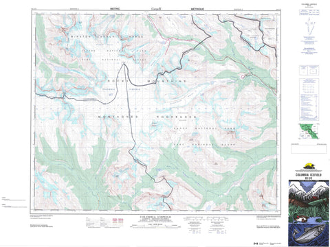
083C03 Columbia Icefield Canada topo map, 1:50,000 scale
083C03 Columbia Icefield NRCAN topographic map.
Includes UTM and GPS geographic coordinates (latitude and longitude). This 50k scale map is suitable for hiking, camping, and exploring, or you could frame it as a wall map.
Printed on-demand using high resolution, on heavy weight and acid free paper, or as an upgrade on a variety of synthetic materials.
Topos available on paper, Waterproof, Poly, or Tyvek. Usually shipping rolled, unless combined with other folded maps in one order.
- Product Number: NRCAN-083C03
- Parent Topo: TOPO-083C
- Map ID also known as: 083C03, 83C3, 83C03
- Unfolded Size: Approximately 26" high by 36" wide
- Weight (paper map): ca. 55 grams
- Map Type: POD NRCAN Topographic Map
- Map Scale: 1:50,000
- Geographical region: Alberta, Canada
Neighboring Maps:
All neighboring Canadian topo maps are available for sale online at 1:50,000 scale.
Purchase the smaller scale map covering this area: Topo-083C
Spatial coverage:
Topo map sheet 083C03 Columbia Icefield covers the following places:
- Weeping Wall - Bridal Veil Falls - Panther Falls - Athabasca Glacier - Castleguard Glacier - Columbia Glacier - Columbia Icefield - Columbia Icefield - Columbia Snowfield - Columbia Snowfield - Dome Glacier - East Rice Glacier - East Rice Glacier - King Edward Glacier - Manitoba Glacier - North Rice Glacier - Saskatchewan Glacier - South Rice Glaciers - Stutfield Glacier - Cinema Lake - Sunwapta Lake - Watchman Lake - Wilcox Lake - Castleguard Mountain - Columbia Mountain - Hilda Peak - Hooge Mountain - Monchy Mountain - Montagnes Rocheuses - Mount Andromeda - Mount Athabasca - Mount Bryce - Mount Bryce - Mount Columbia - Mount Columbia - Mount Douglas - Mount Kitchener - Mount Saskatchewan - Mount Spring-Rice - Mount Spring-Rice - Mount Wilcox - Nigel Peak - North Twin - Parker Ridge - Quéant Mountain - Quéant Mountain - Rocky Mountains - Snow Dome - Snow Dome - South Twin - Stutfield Peak - Terrace Mountain - The Castelets - The Twins - Twins Tower - Watchman Peak - Watchman Peak - Wilcox Peak - Willerval Mountain - Winston Churchill Range - Clearwater County - Columbia-Shuswap Regional District - Municipal District of Clearwater No. 99 - Improvement District No. 12 - Improvement District No. 9 - Banff National Park of Canada - Canadian Rocky Mountain Parks World Heritage Site - Canadian Rocky Mountain Parks World Heritage Site - Jasper National Park of Canada - Parc national du Canada Banff - Parc national du Canada Jasper - Site du patrimoine mondial des Parcs des montagnes Rocheuses canadiennes - Site du patrimoine mondial des Parcs des montagnes Rocheuses canadiennes - White Goat Wilderness Area - Alberta - Alexandra River - Athabasca River - Athabaska River - Brazeau River - Bryce Creek - Bush River - Castleguard River - Cataract Creek - Cline Creek - Hilda Creek - Kitchener Creek - Nigel Creek - North Saskatchewan River - Rice Brook - Ridges Creek - Rivière Athabasca - Rivière Saskatchewan Nord - South Rice Brook - Stutfield Creek - Sullivan River - Sunwapta River - Terrace Creek - Watchman Creek - Cataract Pass - Cline Pass - Narrow Canyon - Nigel Pass - Sunwapta Pass - The Trench - The Trench - Thompson Pass - Thompson Pass - Wilcox Pass - Castleguard Meadows


