
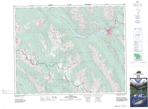
082O04 Banff Canada topo map, 1:50,000 scale
082O04 Banff NRCAN topographic map.
Includes UTM and GPS geographic coordinates (latitude and longitude). This 50k scale map is suitable for hiking, camping, and exploring, or you could frame it as a wall map.
Printed on-demand using high resolution, on heavy weight and acid free paper, or as an upgrade on a variety of synthetic materials.
Topos available on paper, Waterproof, Poly, or Tyvek. Usually shipping rolled, unless combined with other folded maps in one order.
- Product Number: NRCAN-082O04
- Parent Topo: TOPO-082O
- Map ID also known as: 082O04, 82O4, 82O04
- Unfolded Size: Approximately 26" high by 36" wide
- Weight (paper map): ca. 55 grams
- Map Type: POD NRCAN Topographic Map
- Map Scale: 1:50,000
- Geographical region: Alberta, Canada
Neighboring Maps:
All neighboring Canadian topo maps are available for sale online at 1:50,000 scale.
Purchase the smaller scale map covering this area: Topo-082O
Spatial coverage:
Topo map sheet 082O04 Banff covers the following places:
- Goat's Eye - Monarch Ramparts - Bow Falls - Talc Falls - Arnica Lake - Black Rock Lake - Bourgeau Lake - Citadel Lake - Egypt Lake - Eohippus Lake - Fatigue Lakes - Grizzly Lake - Haiduk Lake - Healy Lakes - Howard Douglas Lake - Larix Lake - Mule Shoe Lake - Mummy Lake - Pharaoh Lake - Pilot Pond - Rock Isle Lake - Scarab Lake - Shadow Lake - Smith Lake - Sphinx Lake - Sundown Lake - Talc Lake - Twin Lakes - Two Jack Lake - Vermilion Lakes - Banff Training Area - Champ de manoeuvre Banff - Ball Range - Ball Range - Brewster Rock - Cascade Mountain - Citadel Peak - Citadel Peak - Cockscomb Mountain - Copper Mountain - Eagle Mountain - Fatigue Mountain - Fatigue Mountain - Goat Range - Haiduk Peak - Haiduk Peak - Hawk Ridge - Lookout Mountain - Massive Mountain - Massive Range - Montagnes Rocheuses - Mount Bourgeau - Mount Brett - Mount Brewster - Mount Cory - Mount Edith - Mount Fifi - Mount Howard Douglas - Mount Louis - Mount Norquay - Mount Rundle - Mount Shanks - Park Ranges - Pharaoh Peaks - Pilot Mountain - Quartz Hill - Quartz Hill - Rocky Mountains - Rocky Mountains - Sanson Peak - Sawback Range - Simpson Ridge - Standish Hump - Standish Hump - Standish Ridge - Standish Ridge - Stoney Squaw Mountain - Storm Mountain - Sulphur Mountain - Sundance Range - The Monarch - Tunnel Mountain - Twin Cairns - Twin Cairns - Vermilion Range - Vermillion Range - Wa-wa Ridge - Regional District of East Kootenay - Improvement District No. 9 - Banff National Park of Canada - Banff Park Museum National Historic Site of Canada - Cave and Basin National Historic Site of Canada - Kootenay National Park of Canada - Lieu historique national du Canada Cave and Basin - Lieu historique national du Canada de la Station-d'Étude-des-Rayons-Cosmiques-du-Mont-Sulphur - Lieu historique national du Canada du Musée-du-Parc-Banff - Mount Assiniboine Park - Parc national du Canada Banff - Parc national du Canada Kootenay - Sulphur Mountain Cosmic Ray Station National Historic Site of Canada - Wheeler Flats - Alberta - Altrude Creek - Bow River - Brewster Creek - Cascade River - Douglas Creek - East Verdant Creek - Echo Creek - Eohippus Creek - Fatigue Creek - Forty Mile Creek - Goat Creek - Governor Creek - Haiduk Creek - Hawk Creek - Healy Creek - Howard Douglas Creek - Johnston Creek - Larix Creek - Lost Horse Creek - North Simpson River - Packer Creek - Pharaoh Creek - Ranger Creek - Redearth Creek - Simpson River - Spray River - Sundance Creek - Sunshine Creek - Verdant Creek - Verendrye Creek - Vermilion River - Whiskey Creek - Banff - Bankhead - Massive - Sawback - Vermilion Crossing - Ball Pass - Ball Pass - Citadel Pass - Citadel Pass - Cory Pass - Fatigue Pass - Fatigue Pass - Gargoyle Valley - Gibbon Pass - Harvey Pass - Healy Pass - Johnston Canyon - Ranger Canyon - Redearth Pass - Redearth Pass - Simpson Pass - Simpson Pass - Sundance Canyon - Sundance Pass - Whistling Valley


