
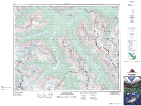
082N15 Mistaya Lake Canada topo map, 1:50,000 scale
082N15 Mistaya Lake NRCAN topographic map.
Includes UTM and GPS geographic coordinates (latitude and longitude). This 50k scale map is suitable for hiking, camping, and exploring, or you could frame it as a wall map.
Printed on-demand using high resolution, on heavy weight and acid free paper, or as an upgrade on a variety of synthetic materials.
Topos available on paper, Waterproof, Poly, or Tyvek. Usually shipping rolled, unless combined with other folded maps in one order.
- Product Number: NRCAN-082N15
- Parent Topo: TOPO-082N
- Map ID also known as: 082N15, 82N15
- Unfolded Size: Approximately 26" high by 36" wide
- Weight (paper map): ca. 55 grams
- Map Type: POD NRCAN Topographic Map
- Map Scale: 1:50,000
- Geographical region: Alberta, Canada
Neighboring Maps:
All neighboring Canadian topo maps are available for sale online at 1:50,000 scale.
Purchase the smaller scale map covering this area: Topo-082N
Spatial coverage:
Topo map sheet 082N15 Mistaya Lake covers the following places:
- Barbette Glacier - Capricorn Glacier - Conway Glacier - East Glacier - Freshfield Glacier - Freshfield Icefield - Lambe Glacier - Mons Glacier - Mons Icefield - Mons Icefield - Murchison Icefield - Niverville Glacier - North Glacier - Pangman Glacier - Sir James Glacier - Snowbird Glacier - South Glacier - Southeast Lyell Glacier - West Glacier - Capricorn Lake - Chephren Lake - Cirque Lake - David Lake - David Thompson Lake - Epaulette Lake - Glacier Lake - Kaufmann Lake - Lagoon Lake - Mistaya Lake - Outram Lake - Warden Lake - Waterfowl Lakes - Aiguille Peak - Aiguille Peak - Arctomys Peak - Aries Peak - Aries Peak - Barnard Dent Group - Barnard Dent Group - Breaker Mountain - Cambrai Mountain - Cambrai Mountain - Conway Group - Conway Group - Corona Ridge - Coronation Mountain - Ebon Peak - Ebon Peak - Epaulette Mountain - Golden Eagle Peak - Howse Peak - Howse Peak - Kaufmann Peaks - Messines Mountain - Messines Mountain - Midway Peak - Midway Peak - Montagnes Rocheuses - Mount Bergne - Mount Chephren - Mount Conway - Mount Conway - Mount David - Mount David Thompson - Mount Dent - Mount Dent - Mount Erasmus - Mount Forbes - Mount Garth - Mount Murchison - Mount Niverville - Mount Noyes - Mount Outram - Mount Pangman - Mount Pangman - Mount Patterson - Mount Sarbach - Mount Skene - Mount Strahan - Mount Synge - Mount Synge - Mount Weed - Pangman Peak - Pangman Peak - Park Ranges - Rocky Mountains - Solitaire Mountain - Stairway Peak - Stairway Peak - Sullivan Peak - Survey Peak - Totem Tower - Waputik Mountains - Waputik Mountains - White Pyramid - Clearwater County - Columbia-Shuswap Regional District - Municipal District of Clearwater No. 99 - Regional District of Kootenay-Boundary - Improvement District No. 9 - Banff National Park of Canada - Howse Pass National Historic Site of Canada - Lieu historique national du Canada du Col-Howse - Parc national du Canada Banff - Siffleur Wilderness Area - Alpland Creek - Arctomys Creek - Bison Creek - Blaeberry River - Breaker Creek - Conway Creek - Corona Creek - David Creek - David Thompson Creek - Ebon Creek - Epaulette Creek - Forbes Brook - Forbes Creek - Freshfield Brook - Freshfield Creek - Glacier River - Howse River - Kaufmann Creek - Mistaya River - Murchison Creek - North Saskatchewan River - Noyes Creek - Owen Creek - Porcupine Creek - Rivière Saskatchewan Nord - Sarbach Creek - Silverhorn Creek - Spreading Creek - Totem Creek - Valenciennes River - Saskatchewan River Crossing - Bush Pass - Bush Pass - Howse Pass - Howse Pass - Mistaya Canyon - Valley of Lakes


