
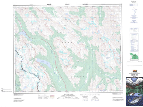
082N09 Hector Lake Canada topo map, 1:50,000 scale
082N09 Hector Lake NRCAN topographic map.
Includes UTM and GPS geographic coordinates (latitude and longitude). This 50k scale map is suitable for hiking, camping, and exploring, or you could frame it as a wall map.
Printed on-demand using high resolution, on heavy weight and acid free paper, or as an upgrade on a variety of synthetic materials.
Topos available on paper, Waterproof, Poly, or Tyvek. Usually shipping rolled, unless combined with other folded maps in one order.
- Product Number: NRCAN-082N09
- Parent Topo: TOPO-082N
- Map ID also known as: 082N09, 82N9, 82N09
- Unfolded Size: Approximately 26" high by 36" wide
- Weight (paper map): ca. 55 grams
- Map Type: POD NRCAN Topographic Map
- Map Scale: 1:50,000
- Geographical region: Alberta, Canada
Neighboring Maps:
All neighboring Canadian topo maps are available for sale online at 1:50,000 scale.
Purchase the smaller scale map covering this area: Topo-082N
Spatial coverage:
Topo map sheet 082N09 Hector Lake covers the following places:
- Wall of Jericho - Angels Staircase Falls - Point Lace Falls - Takakkaw Falls - Balfour Glacier - Bath Glacier - Crowfoot Glacier - Daly Glacier - Diableret Glacier - Drummond Glacier - Fairy Glacier - Hector Glacier - Molar Glacier - Niles Glacier - Trolltinder Glacier - Vulture Glacier - Vulture Glacier - Wapta Icefield - Wapta Icefield - Waputik Glacier - Waputik Icefield - Waputik Icefield - Waputik Snowfield - Bow Lake - Castilleja Lake - Devon Lakes - Fairy Lake - Fish Lakes - Hector Lake - Lake Alice - Lake Duchesnay - Lake Helen - Lake Katherine - Lake Margaret - Lake Merlin - Myosotis Lake - Oyster Lake - Red Deer Lakes - Skoki Lakes - Turquoise Lake - Zigadenus Lake - Bow Peak - Cataract Peak - Cirque Peak - Clearwater Mountain - Crowfoot Mountain - Cyclone Mountain - Devon Mountain - Dip Slope Mountain - Dolomite Peak - Fossil Mountain - Lilliput Mountain - Lilliput Mountain - Little Cataract Mountain - Merlin Castle - Merlin Ridge - Molar Mountain - Montagnes Rocheuses - Mosquito Mountain - Mount Balfour - Mount Balfour - Mount Daly - Mount Daly - Mount Drummond - Mount Hector - Mount McConnell - Mount Niles - Mount Olive - Mount Olive - Noseeum Mountain - Observation Peak - Oyster Peak - Pipestone Mountain - Pulpit Peak - Rocky Mountains - Sawback Range - Skoki Mountain - Slate Mountains - Slate Range - St. Nicholas Peak - St. Nicholas Peak - The Three Brothers - Trolltinder Mountain - Waputik Mountains - Waputik Mountains - Waputik Peak - Waputik Range - Columbia-Shuswap Regional District - Regional District of Kootenay-Boundary - Improvement District No. 9 - Banff National Park of Canada - Lieu historique national du Canada de l'Auberge-de-Ski-Skoki - Parc national du Canada Banff - Parc national du Canada Yoho - Skoki Ski Lodge National Historic Site of Canada - T{26}'il{27}os Park - Yoho National Park of Canada - Balfour Creek - Bath Creek - Bow River - Clearwater River - Fairy Creek - Hector Creek - Helen Creek - Little Pipestone Creek - McConnell Creek - Molar Creek - Mosquito Creek - Mosquito Creek - Noseeum Creek - Noseeum Creek - Pipestone River - Red Deer River - Roaring Creek - Siffleur River - Waves Creek - Yoho River - Balfour Pass - Balfour Pass - Bow Pass - Clearwater Pass - Dolomite Pass - Merlin Valley - Molar Pass - North Molar Pass - Pipestone Pass - Skoki Valley - Vulture Col - Yoho Valley


