
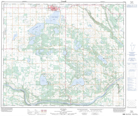
073E14 St Paul Canada topo map, 1:50,000 scale
073E14 St Paul NRCAN topographic map.
Includes UTM and GPS geographic coordinates (latitude and longitude). This 50k scale map is suitable for hiking, camping, and exploring, or you could frame it as a wall map.
Printed on-demand using high resolution, on heavy weight and acid free paper, or as an upgrade on a variety of synthetic materials.
Topos available on paper, Waterproof, Poly, or Tyvek. Usually shipping rolled, unless combined with other folded maps in one order.
- Product Number: NRCAN-073E14
- Parent Topo: TOPO-073E
- Map ID also known as: 073E14, 73E14
- Unfolded Size: Approximately 26" high by 36" wide
- Weight (paper map): ca. 55 grams
- Map Type: POD NRCAN Topographic Map
- Map Scale: 1:50,000
- Geographical region: Alberta, Canada
Neighboring Maps:
All neighboring Canadian topo maps are available for sale online at 1:50,000 scale.
Purchase the smaller scale map covering this area: Topo-073E
Spatial coverage:
Topo map sheet 073E14 St Paul covers the following places:
- Saddle Lake 125 - Fort Island - Calder Lake - Camp Lake - Dolo Lake - Felix Lake - Hobden Lake - Hook Lake - Lac Bellevue - Lac Berard - Lac Canard - Lac Cyr - Lac Delorme - Lac Flammand - Lac Poitras - Lac Saint Cyr - Lake Eliza - Lower Thérien Lake - Myr Lake - Rosinan Lake - Stoney Lake - Stony Lake - Upper Thérien Lake - Moose Hills - County of St. Paul No. 19 - County of Two Hills No. 21 - Blue Quills National Wildlife Area - Réserve nationale de faune de Blue Quills - Atimoswe Creek - Crookedheel Creek - Dog Rump Creek - North Saskatchewan River - Rivière Saskatchewan Nord - Siler Creek - Slawa Creek - St. Paul - St. Paul des Métis - Armistice - Edouardville - Lac Bellevue - Lac Canard - Lafond - Lake Eliza - St. Edouard - Stony Lake


