
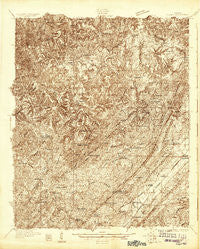
~ Adger AL topo map, 1:48000 scale, 15 X 15 Minute, Historical, 1927
Adger, Alabama, USGS topographic map dated 1927.
Includes geographic coordinates (latitude and longitude). This topographic map is suitable for hiking, camping, and exploring, or framing it as a wall map.
Printed on-demand using high resolution imagery, on heavy weight and acid free paper, or alternatively on a variety of synthetic materials.
Topos available on paper, Waterproof, Poly, or Tyvek. Usually shipping rolled, unless combined with other folded maps in one order.
- Product Number: USGS-5678304
- Free digital map download (high-resolution, GeoPDF): Adger, Alabama (file size: 21 MB)
- Map Size: please refer to the dimensions of the GeoPDF map above
- Weight (paper map): ca. 55 grams
- Map Type: POD USGS Topographic Map
- Map Series: HTMC
- Map Verison: Historical
- Cell ID: 64797
- Scan ID: 305448
- Survey Year: 1927
- Datum: NAD
- Map Projection: Polyconic
- Advance: Yes
- Map published by United States Geological Survey
- Keywords: Overedge; Nonstandard Press Run
- Map Language: English
- Scanner Resolution: 600 dpi
- Map Cell Name: Yolande
- Grid size: 15 X 15 Minute
- Date on map: 1927
- Map Scale: 1:48000
- Geographical region: Alabama, United States
Neighboring Maps:
All neighboring USGS topo maps are available for sale online at a variety of scales.
Spatial coverage:
Topo map Adger, Alabama, covers the geographical area associated the following places:
- North Johns - Yolande - Johns - Lowetown - Pattersontown - Chinn - Bullard Shoals (historical) - Valley Creek - McCalla - Mud Creek - Ezra - Rock Creek - Red Hill Heights - McAdory - Adger - Oak Grove - Tannehill - Abernant - Bucksville - Rickey - Concord - Vines Mill - Black Diamond - Tannehill Valley Estates - Blue Creek - Sumter - Kimbrell - Lakeview Estates - Confederate Hill Estates - Virginia - Lake View - Hopkins - Lawsontown - Toadvine - Flint Hill - Weller - Cloester Valley - Million Dollar Lake Estates
- Map Area ID: AREA33.533.25-87.25-87
- Northwest corner Lat/Long code: USGSNW33.5-87.25
- Northeast corner Lat/Long code: USGSNE33.5-87
- Southwest corner Lat/Long code: USGSSW33.25-87.25
- Southeast corner Lat/Long code: USGSSE33.25-87
- Northern map edge Latitude: 33.5
- Southern map edge Latitude: 33.25
- Western map edge Longitude: -87.25
- Eastern map edge Longitude: -87


